How to drive the high mountain road to Alto del Chorrillo in Granada?
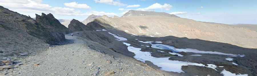
Alto del Chorrillo is a high mountain summit reaching 2,691 meters (8,828 ft) above sea level in the Sierra Nevada range, located in the province of Granada, Spain. This point is home to one of the highest mountain roads in Spain. Known as the Camino de los Franceses or Camino del Mulhacén, this track was once a legendary 4x4 route linking Capileira with the Veleta peak. Today, it remains a brutal test of endurance in a high-alpine desert where the air is thin, the wind is relentless, and the track surface is a chaotic mix of loose gravel and jagged rocks that define the rugged character of Andalusia's highest peaks.
| Road facts: Alto del Chorrillo | |
|---|---|
| Location | Sierra Nevada, Granada, Spain |
| Elevation | 2,691m (8,828ft) |
| Length | 23.3 km (14.4 miles) |
| Access | Restricted (Bicycles / Authorized only) |
How difficult is the road to Alto del Chorrillo?
The 23.3-kilometer journey from the small town of Capileira to the high ridges of the Mulhacén is an exercise in high-altitude logistics. The road is entirely unpaved, consisting of a gravel and rock surface that is "tippy" and extremely bumpy. For those authorized to drive it, a high-clearance 4x4 is essential to navigate the deep ruts and shifting stones. The track is notorious for its steep sections where traction is hard to find, especially on the hairpin curves that skirt dangerous drop-offs. It is a slow-speed crawl where every meter gained puts extra stress on the cooling system and the suspension as you trundle through the mineral landscape of the Sierra Nevada National Park.
What are the main hazards on the Camino de los Franceses?
The primary hazard at Alto del Chorrillo is the volatile high-mountain environment. Even in summer, sudden storms can turn the dry dust into a slippery trap. The road is totally impassable in winter, buried under meters of snow and subject to avalanches and heavy ice patches that remain well into July. Landslides are common, often narrowing the already tight path and leaving jagged debris that can easily slice through tires. The exposure is total; the dangerous drop-offs provide zero margin for error, and for anyone scared of heights, the constant view of the precipices during the climb can be overwhelming. High-altitude winds are also a major factor, capable of unsettling a vehicle on the more exposed ledge sections.
Can you drive a private vehicle to Alto del Chorrillo?
Currently, to protect the wilderness of the National Park, access for private motor vehicles is strictly prohibited. The road is primarily used by park rangers, official shuttles, and bicycles. This restriction has kept the area pristine, but it hasn't made the road any easier. For cyclists or authorized personnel, the physical reality of the 2,691-meter altitude means a 30% loss of oxygen efficiency, making the steep ramps feel twice as hard. If you are on a bike, the high-frequency vibration from the "rocky and bumpy" surface will test every bolt on your frame and your own physical limits during the long haul from Capileira.
How long is the road to the summit?
The full route covers 23.3 kilometers (14.4 miles) of unrelenting ascent. Starting from the lower valleys of the Alpujarra, you climb thousands of vertical meters to reach the barren slopes near the Veleta. This is a sustained high-altitude climb where the lack of shade and the intensity of the sun can cause engines to boil over if they aren't in perfect condition. The track follows the spine of the mountains, offering no escape routes or easy turn-arounds. It is a one-way-up, one-way-down scenario where the mechanics of your vehicle—or your legs—are the only thing standing between you and the deep isolation of the Mulhacén massif.
What mechanical prep is needed for the Sierra Nevada climb?
For any authorized vehicle, the cooling system is the most critical component. A slow-speed climb to nearly 2,700 meters on an unpaved surface means very little airflow reaches the radiator. Check your tire sidewalls for damage; the sharp shale of Granada is expert at destroying rubber. On the descent back toward Capileira, do not ride your brakes. The sustained steepness will cause brake fade within minutes. Use engine braking in low gears to maintain control. For those on bicycles, verify your brake pads and tire pressure, as the long descent on jagged gravel is a torture test for any rim or disc system. Carry plenty of water and survival gear, as the weather at Alto del Chorrillo can shift from a heatwave to a freezing gale in less than an hour.
Pic: Ramón Carlos Válor López