Conquering Collado El Lobo in Sierra Nevada
Located in the heart of the Sierra Nevada National Park, Collado El Lobo is one of the most extreme geographical points in the Iberian Peninsula. Reaching a staggering elevation of 3,115m (10,219ft) above sea level, this mountain pass sits on the high-altitude track known as the Camino de los Franceses. It is a place defined by thin air, shifting shale, and a legislative protection that has turned what was once a vehicle road into a legendary challenge for high-altitude logistics.
| Road facts: Collado El Lobo | |
|---|---|
| Location | Granada, Andalusia (Spain) |
| Elevation | 3,115 m (10,219 ft) |
| Road Name | Camino de los Franceses (Camino del Mulhacén) |
| Length | 23.3 km |
| Access | Strictly restricted (National Park rules) |
Where exactly is Collado El Lobo?
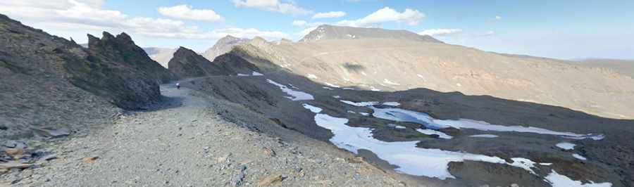
The pass is situated in the province of Granada, marking one of the highest sectors of the highest mountain passes in Spain. It acts as a high-altitude balcony over the southern slopes of the Sierra Nevada, positioned between the Veleta peak and the Mulhacén. The terrain is purely alpine—a desert of rock and slate where vegetation is almost non-existent and the weather is governed by the proximity of the Mediterranean and the high-altitude jet streams.
Is the road to Collado El Lobo unpaved?
The entire transit is totally unpaved. The surface of the Camino de los Franceses is a chaotic mix of loose shale, crushed stone, and bedrock. In the higher sections near the Collado, the track is constantly shifting due to the extreme freeze-thaw cycles. This is a technical terrain where traction is a constant struggle; the stones act like ball bearings under any type of tire. While it was once used by 4x4 vehicles for park maintenance, the surface has degraded over the years, leaving deep ruts and sharp rocky steps that require surgical precision to navigate.
How long and technical is the route?
The route spans 23.3 km (14.47 miles), running north-south from the area near the Veleta peak down to the village of Capileira. It is a long-distance mission through an environment where the lack of oxygen reduces physical and mechanical performance by nearly 30%. The technicality lies in the exposure; the track is narrow, with vertical drops that offer zero margin for error. The southern side, descending toward the Alpujarra, features steep ramps where the loose surface makes braking an exercise in controlled sliding.
Is the road through Collado El Lobo open to vehicles?
No. This is a critical point for any traveler: to protect the wilderness of the National Park, motorized transit is strictly prohibited. Only authorized park vehicles and bicycles are allowed on this track. Heavy fines are imposed on anyone attempting to cross with a motorcycle or a 4x4. Beyond the legal restrictions, the road is considered one of the highest roads in Europe, but it remains totally impassable for most of the year due to heavy snowfalls and avalanches that block the path until mid-summer.
What are the main hazards of this high-altitude transit?
The primary hazard is the altitude and the weather. At 3,115m, mountain sickness is a real threat, and sudden blizzards can reduce visibility to zero in minutes even in July. The descents are brutal; whether on a bike or in an authorized vehicle, the sustained steepness will overheat braking systems rapidly. You must manage your speed using the terrain and avoid constant friction. The Camino de los Franceses is a lesson in mountain respect—check the regulations, monitor the clouds, and never underestimate the power of the Sierra Nevada winds at the Collado El Lobo.
Pic: Ramón Carlos Válor López