Driving the unpaved track to La Polarda: 2,143m in Sierra Nevada
Located in the eastern section of the Sierra Nevada National Park, in the province of Almería, the ascent to La Polarda is one of the highest and most isolated unpaved transits in Southern Spain. Reaching an elevation of 2,143m (7,030ft) above sea level, the track follows the high ridges of the mountain range, offering a raw driving experience where the desert-like heat of Almería meets the thin, freezing air of the summits. It is a route for those looking to test their vehicle's endurance on a long, sustained climb far from any paved civilization.
| Road facts: La Polarda | |
|---|---|
| Location | Almería, Andalusia (Spain) |
| Elevation | 2,143 m (7,030 ft) |
| Length | 16 km (from Puerto de Santillana) |
| Elevation Gain | 767 m |
| Surface | Unpaved / Loose shale and gravel |
Is the road to the summit of La Polarda paved?
No, the road is totally unpaved and becomes increasingly technical as you gain altitude. Starting from the Puerto de Santillana, the 16 km climb is a mix of packed dirt and loose shale. You absolutely need a 4x4 vehicle with high clearance; the track is often damaged by heavy mountain runoff, leaving deep ruts and exposed rocks that can easily catch the low points of a standard car. The surface is deceptive; in dry weather, the dust makes the steep sections incredibly slippery, and in winter, the mud from the snowmelt creates a traction trap that can leave you stranded in one of the most remote corners of Andalusia.
How steep is the drive to La Polarda?
The climb covers an elevation gain of 767 meters with an average gradient of 4.79%. However, these numbers don't tell the whole story. The trail features several pretty steep ramps where the incline hits double digits on a very loose surface. Maintaining a constant momentum is key here; if you stop on the steepest sections, restarting the vehicle on the sliding gravel is a technical challenge that will put a heavy strain on your transmission and tires. The final kilometers toward the 2,143m summit are the most exposed, where the wind can be strong enough to buffeting the vehicle as you navigate the narrow ridge track.
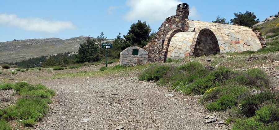
What can you find at the summit of La Polarda?
At the very top, there is a mountain refuge that serves as a shelter for hikers and forest workers. Logistically, reaching this point is a milestone because of the absolute isolation. There are no services, no cell coverage, and no margin for error. You must ensure your vehicle is in top mechanical condition and that you carry enough fuel and a full-size spare. The altitude at over 2,100 meters will sap some of your engine's power, so don't expect the same throttle response you get at sea level in Almería.
How do you manage the 16 km descent back to Santillana?
The 16 km trip down is a long test of vehicle control. Because the road is unpaved and often narrow, you cannot afford to build up too much speed. If you rely solely on your brake pedal, you risk overheating your system or, worse, sliding on the loose gravel. The safest way down is to engage heavy engine braking and pick your line through the most stable parts of the track. Watch the shoulders of the road; they are soft and eroding, and a single tire slipping off the edge can lead to a dangerous situation on the unprotected slopes of Sierra Nevada.
Pic: fcardila