How is the drive to Puerto de San Rafael in Teruel?
Puerto de San Rafael is a lonely sentinel in the heart of the Iberian System. At an elevation of 1,560m (5,118ft) above sea level, this pass in the province of Teruel is a far cry from the smooth, high-speed highways of the plains. The A-228 road, which crosses this summit, offers a raw driving experience through one of the most depopulated and rugged regions of Aragon. It is a route where the silence of the mountains is only broken by the sound of tires struggling against aging asphalt.
| Road facts: Puerto de San Rafael (A-228) | |
|---|---|
| Location | Teruel, Aragon (Spain) |
| Elevation | 1,560m (5,118ft) |
| Length | 33.6 km (20.8 miles) |
| Max Gradient | 9.3% |
| Surface | Asphalt (Worn and patched) |
How long is the road to Puerto de San Rafael?
The journey across the pass covers 33.6 km (20.8 miles) along the A-228, connecting the villages of Allepuz and Mora de Rubielos. This is not a road for those in a hurry. The route winds through a landscape of pine forests and limestone outcrops, gaining height steadily. While the climb is famous for its appearances in the Vuelta a España, for the everyday driver, the challenge lies in the endurance required to maintain a steady pace on a road that feels increasingly isolated as you climb toward the 1,560-meter mark.
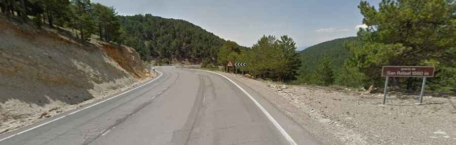
What is the road surface like on the A-228?
The asphalt on Puerto de San Rafael, also known as Alto de San Rafael, tells the story of harsh winters and lack of maintenance. As seen on the ground, the surface is heavily worn, with numerous patches and cracks that can unsettle a vehicle's suspension. The road markings are often faded, making it difficult to judge the edges of the lane during rain or fog. The grip level is inconsistent, and in some sections, the road narrows significantly, forcing you to stay alert for oncoming trucks or farm machinery that might take up more than their fair share of the space.
[Image showing the worn and patched asphalt of the A-228 road climbing through the pine forests of Teruel]
How steep is the climb to Puerto de San Rafael?
The climb features several steep sections with gradients reaching up to 9.3%. While it might not have the extreme percentages of the Picos de Europa, the length of the slopes and the constant gear changes required can put a strain on your brakes and transmission. On the descent toward Mora de Rubielos, you need to manage your speed carefully; the combination of old asphalt and tight bends means that traction can be unpredictable. If your tires are nearing the end of their life, the A-228 will let you know very quickly.
What are the hazards of driving in the Iberian System?
The main hazards on this pass are weather and animals. Being in one of the coldest parts of Spain, ice is a constant threat from late autumn to early spring. Even when the sun is out, the shadows of the pine trees can hide treacherous black ice patches in the corners. Additionally, this is deer and wild boar territory. Crossing these mountains at dusk or dawn is a gamble, as animals frequently leap onto the road without warning. There are no guardrails in many sections, so a sudden swerve to avoid an animal could end with your car in the ditch or worse.
Driving the Puerto de San Rafael is about embracing the emptiness of Teruel. It is a road that demands a calm hand and a respect for the aging infrastructure. Check your spare tire before you start, keep an eye out for wildlife, and don't expect a smooth ride. The A-228 is a journey through a forgotten landscape where the road and the mountains are slowly becoming one. Stay sharp.