A narrow road to the wild Picon Blanco in the Cantabrian Mountains
Picón Blanco is a high mountain peak at an elevation of 1.512m (4,960ft) above sea level, located in the province of Burgos, in the autonomous community of Castile and León of Spain.
Why is it called Picon Blanco?
The peak gets its name (White Peak) from the snow that accumulates in winter.
Where is Picon Blanco?
The peak is located in the Cantabrian Mountains near the border with the autonomous community of Cantabria, in the northern part of the country.
Why is Picon Blanco famous?
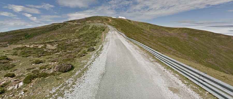
The summit hosts an abandoned military base, part of the Centro de Transmisiones CT-9 de la Unidad de Ingenieros del Ejército, built in the 1970s and abandoned in 1999. A narrow, unpaved road to the west of the summit connects the pass with Puerto de la Sía pass. Spanning 4.8 km, this route is best suited for 4x4 vehicles and is typically impassable in winter.
How long is the road to Picon Blanco?
The road to the summit, built to service the old military base, is fully paved but in poor condition due to the weather. Starting from Espinosa de los Monteros, the ascent is 8 km (4.97 miles) long, with an elevation gain of 740 meters, averaging a gradient of 9.25%.
How wild is the climb to Picon Blanco?
The climb to the summit is demanding and has been a final stage in the Vuelta a Burgos and the Spanish Vuelta races. Though the challenging pass isn't very long, it features very steep sections with an average gradient of 11% to 12%. In some stretches, the gradient hits a 20.6%.