Camino del Barranco de San Juan: Driving the Old Tramway Tunnels of Sierra Nevada
The Camino del Barranco de San Juan is a narrow mountain road located in the province of Granada, Andalusia, in Spain. Starting from the municipality of Güéjar Sierra, the route tracks the deep valley of the Genil River. It's the only vehicular access to the trailhead of the Vereda de la Estrella hiking route.
| Road facts: Camino del Barranco de San Juan | |
|---|---|
| Location | Güéjar Sierra, Granada, Andalusia, Spain |
| Length | 5.4 km (3.3 miles) from Güéjar Sierra |
| Surface | Asphalt and concrete patches / Single lane |
| Tunnels | 4 unlit rock tunnels |
What is the history of the Barranco de San Juan road infrastructure?
The modern road layout is built entirely on the abandoned trackbed of the Sierra Nevada Tramway, an alpine railway system operated between 1925 and 1974 to connect Granada with the mining areas of the valley. Following the closure of the line, the steel rails were removed, and the narrow platform was coated with a basic layer of asphalt to open up access for cars, vans, and agricultural vehicles heading into the high mountain basin.
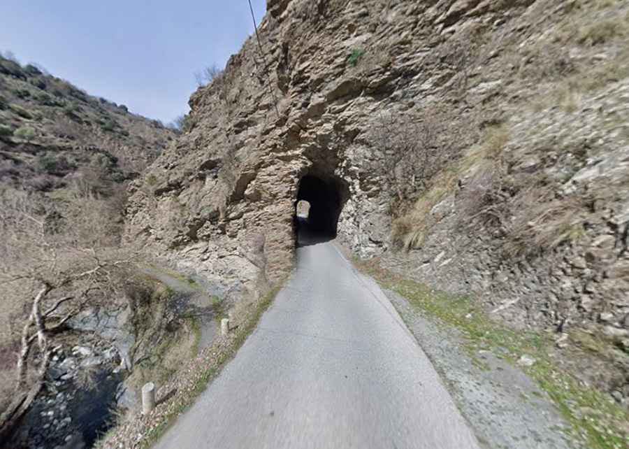
What are the dimensions of the tramway tunnels?
The 5.4 km route crosses at least 4 narrow tunnels carved directly out of the jagged shale and limestone rock faces. These openings preserve the original narrow gauge railway clearances, measuring barely 2.5 meters wide, meaning two cars cannot pass inside under any circumstances. The interiors are rough rock walls without concrete lining or artificial reinforcing beams, and they completely lack illumination systems, requiring drivers to switch on headlights well before entering.
How narrow is the road from Güéjar Sierra?
The entire 5.4 km road is strictly single-lane wide with zero painted centerlines or asphalt shoulders. It drops down from the village toward the river bed via tight bends flanked by vertical mountain slopes on one side and unprotected drops into the Genil River canyon on the other. Because the lane is only wide enough for one vehicle, encountering oncoming traffic requires one driver to back up to the nearest dirt turnout or wider clearing along the cliffside.
Where does the road terminate?
Vehicular transit ends at the Barranco de San Juan parking area, a rough dirt and gravel clearing situated next to the rushing river. At this point, an iron gate blocks all motorized access. Beyond this parking sector, the route transitions into the unpaved Vereda de la Estrella trail, an old mule path that climbs into the core of the Sierra Nevada National Park, restricted entirely to foot traffic and non-motorized mountain bikes.