How to drive the unpaved road to Pico Cervín in Ribagorza?
Pico Cervín is a high mountain peak at an elevation of 1,620m (5,314ft) above sea level, located in the Ribagorza county, within the province of Huesca, Spain.
Where is Pico Cervín located?
The peak, also known as Tozal de la Rasa, is situated in the central Pyrenees of Huesca, over the Esera valley.
Why is there a road to the summit of Pico Cervín?
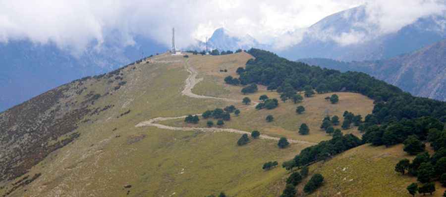
The road was built and is currently maintained to provide access to the large communication towers and antennas located at the top (Tozal de la Rasa). The road is used by maintenance crews to reach the antennas at the summit.
How long is the road to Pico Cervín?
The road to the summit starts directly from the N-260 paved highway. Over a distance of 9.2 kilometers, you gain 844 meters of elevation, resulting in a brutal average gradient of 9.17%. While the track is generally kept clear for technicians, it is not designed for tourist traffic.
Is a 4x4 required to drive to Pico Cervín?
Set high in the Cervín mountain range, a high-clearance 4x4 vehicle is strictly required. The road is entirely unpaved and the surface alternates between compact soil and sections of loose, sharp limestone gravel. The track is exceptionally narrow, with several hairpins where a standard car would struggle with both traction and ground clearance. There are no safety barriers, and the edges of the road are often exposed with vertical drops. In some parts, the limestone rocks can be sharp enough to damage standard road tires.
Pic&more info: http://danielmurmarin.blogspot.com/2010/11/cervin-1684-m.html