Is the road to Sant Llorenç de Montgai reservoir dangerous to drive?
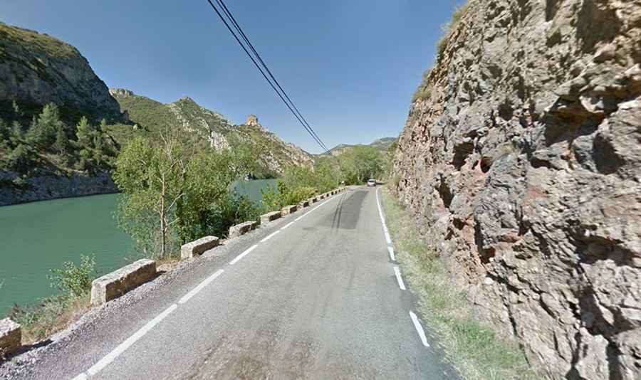
Driving along the Sant Llorenç de Montgai reservoir is a constant tension between the steering wheel and the water. Located in the Noguera region, in the province of Lleida, this stretch of the LV-9047 road is far from a relaxed drive through the Pre-Pyrenees. It is a narrow strip of asphalt that skirts the Segre river as it feeds the reservoir, leaving drivers with almost no room for maneuver between the limestone cliffs and the deep water.
| Road facts: Sant Llorenç de Montgai (LV-9047) | |
|---|---|
| Location | Lleida, Catalonia (Spain) |
| Road Name | LV-9047 |
| Length | 12.1 km (7.5 miles) |
| Main Hazard | Extremely narrow lane / No protections |
| River | Segre |
How long is the road to Sant Llorenç de Montgai?
The LV-9047 runs for 12.1 km (7.5 miles), connecting the towns of Balaguer and Camarasa. While the southern part is relatively standard, the northern section near the dam is where things get complicated. The road is fully paved, but don't let that fool you into thinking it's an easy ride. As you approach the reservoir, the width of the road shrinks until it becomes a single lane where two cars simply cannot pass each other. You have to look far ahead to anticipate any oncoming traffic, or you'll find yourself forced into a long and nerve-wracking reverse move with a rock wall on one side and a drop into the Segre on the other.
Why is the LV-9047 road along the reservoir so scary?
The real challenge of this journey is the northern shore of the reservoir. For several kilometers, the asphalt runs right at the water level, often without any guardrails or stone walls to stop a vehicle from sliding into the depths. The sensation of driving with the Segre river just a few inches from your tires is intense. In some sections, the overhanging rocks force you to move even closer to the edge. If the water level is high after heavy rains, the boundary between the road and the reservoir practically disappears. It is a psychological test as much as a mechanical one; you need to keep your eyes on the narrow path and ignore the massive body of water inches away.
What are the main hazards near Sant Llorenç de Montgai?
Beyond the narrowness, the main hazard is the lack of visibility in the curves. The road follows the natural contour of the Segre’s canyon, meaning every bend is blind. Local traffic, including cyclists and the occasional delivery van, can appear out of nowhere. Because there is no shoulder and the lane is barely wide enough for a single car, any mistake in choosing your line can lead to scraped paint against the jagged rocks or, worse, a fall into the reservoir. There is no room to dodge or pull over; you are committed to the track until it opens up again near Camarasa.
What is the best way to drive to Sant Llorenç de Montgai?
Patience is your best tool here. Drive slowly, especially in the sections where the road turns into a one-way bottleneck. Using your horn before the tightest blind corners is a common local practice to warn anyone coming from the opposite direction. Ensure your mirrors are tucked in if you see a wide vehicle approaching from afar, and always be ready to yield. The area is popular for rock climbing and bird watching, so expect people parked in the few small turnouts available. It’s a beautiful drive, but one that demands your full attention on the asphalt and a steady hand on the wheel to avoid a soak in the Segre.
The road along Sant Llorenç de Montgai is a masterclass in precision driving. It reminds you that even a paved road can be as demanding as any mountain track when the space is limited and the water is deep. Keep your cool, watch the line, and don't let the rock walls hem you in. The Noguera region doesn't forgive those who get distracted by the view. Stay sharp and stay on the pavement.