Driving logistics and restrictions at Portillo de Rio Seco in Sierra Nevada
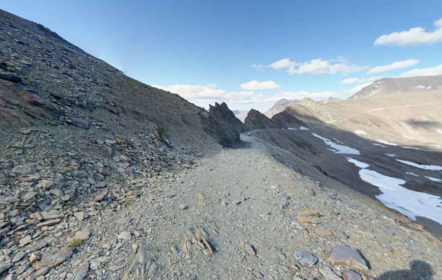
Portillo de Rio Seco is a high mountain pass at an elevation of 3,100m (10,170ft) above sea level, located in the Sierra Nevada range of Granada, Spain. It stands as one of the highest roads in Spain and is featured on the list of the highest roads in Europe, forming part of a critical high-altitude traverse between the northern and southern slopes of the massif.
| Road facts: Portillo de Rio Seco | |
|---|---|
| Location | Sierra Nevada, Granada (Spain) |
| Elevation | 3,100 m (10,170 ft) |
| Road Name | Camino de los Franceses (Pista del Mulhacén) |
| Length | 23.3 km (14.47 miles) |
| Surface | Unpaved / High-Altitude Scree |
Where is Portillo de Rio Seco?
The pass, also known as Portillo de Rioseco, is situated in the southern part of Spain, within the Sierra Nevada National Park. Technically, it is located on the ridgeline that separates the glacial cirques of the upper Genil valley from the southern Alpujarra valleys. Logistically, the pass is an extreme high-altitude environment where atmospheric pressure is significantly reduced, affecting both human physiology and the performance of internal combustion engines during authorized service transits.
Is the road to Portillo de Rio Seco unpaved?
Yes, the 23.3 km (14.47 miles) route through the pass, technically known as the Camino de los Franceses or Pista del Mulhacén, is entirely unpaved. The surface consists of decomposed schist and loose mountain scree, which is highly unstable and prone to erosion. Logistically, the road crosses multiple secondary summits and offers zero protection against the steep drops into the alpine lakes below. The track's technical integrity is constantly compromised by freeze-thaw cycles that displace rocks onto the roadbed, requiring constant maintenance for the passage of National Park service vehicles.
How long is the road through Portillo de Rio Seco?
The 23.3 km (14.47 miles) track runs north-south, connecting the base of the Veleta Peak with the village of Capileira. Technically, this is one of the highest road corridors in the continent, gaining hundreds of meters in elevation over rugged, non-stabilized terrain. Logistically, the 23.3 km transit is a **low-speed operation** due to the extreme incline and the presence of sharp rocks that can compromise tire integrity. There are no services, fuel, or shelter along the entire high-altitude stretch, requiring total self-sufficiency for any authorized vehicle.
Is the road through Portillo de Rio Seco open?
Logistically, the road is totally closed to private motor vehicle traffic to protect the high-mountain ecosystem. Access is strictly limited to National Park authorized vehicles and bicycles. Technically, the road is completely impassable during winter and well into the summer, as snowdrifts and "neveros" (permanent snow patches) block the path until at least July. Extreme weather hazards, including high-velocity winds and sudden electrical storms, make the 3,100m summit a high-risk zone. Furthermore, the route is subject to landslides and rockfalls that can block the 23.3 km path without warning, making it one of the most volatile technical tracks in the country.
Pic: Ramón Carlos Válor López