Is the road to Albergue de San Francisco in Sierra Nevada difficult to drive?
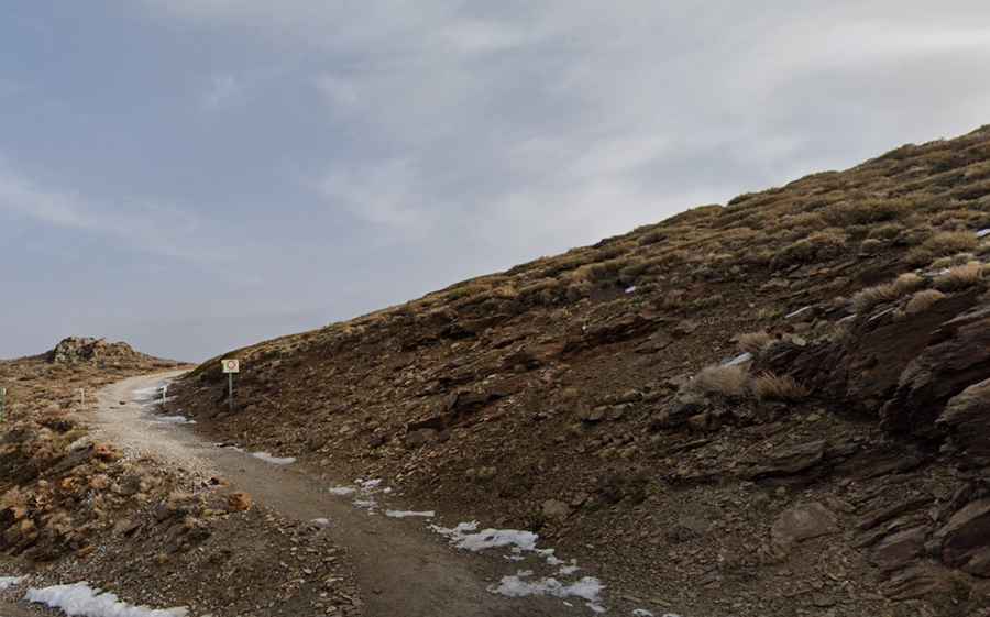
Reaching the Albergue de San Francisco is a journey into the high, thin air of the Sierra Nevada. At 2,206m (7,237ft) above sea level, this historic refuge in the province of Granada is a landmark of the Penibaetic System. But don't let the "scenic" label fool you; the access is a raw, unpaved mountain track that carves through the San Juan Valley. This isn't a road for a Sunday cruise; it’s a restricted backcountry route where the rocks are sharp and the weather can flip from baking sun to a freezing gale in minutes.
| Road facts: Albergue de San Francisco | |
|---|---|
| Location | Sierra Nevada, Granada (Spain) |
| Elevation | 2,206m (7,237ft) |
| Length | 2.1 km (1.3 miles) |
| Starting Point | Collado del Diablo |
| Surface | Unpaved / Rock Track / Restricted Access |
How long is the road to Albergue de San Francisco?
The climb starts at the scenic Collado del Diablo and runs for 2.1 km (1.3 miles) toward the refuge. While the distance is short, you are leaving the asphalt behind for a steep, loose-surface grind. The track overlooks the dramatic glacial cirques of the San Juan Valley, providing a direct line of sight to the Veleta peak. It’s a slow ascent where you have to pick your line carefully among the ruts and stones, as the thin air at over 2,200 meters will make your engine work significantly harder than on the coast.
Is the road to Albergue de San Francisco unpaved?
The entire track is strictly unpaved, consisting of a mix of dry earth and jagged Sierra Nevada shale. It’s important to note that private motorized vehicles are banned; the road is blocked by a locked gate and a chain. Only authorized personnel or National Park rangers can drive here. If you have the permit, a high-clearance 4x4 is a must—the track is uneven, narrow, and has several steep sections that will make a standard SUV's tires spin. For everyone else, this 2.1 km stretch is a high-altitude hike where the "road" is just a rough guide through the rocky meadows.
What are the hazards when driving to Albergue de San Francisco?
The primary danger on this track is the **unpredictable mountain weather**. Thunderstorms in Granada can develop in minutes during the afternoon, turning the rocky path into a slippery trap. The wind on these exposed ridges can be brutal, and the sun at this elevation will burn your skin and dazzle your eyes before you realize it. During the winter (November to May), the road simply disappears under meters of snow. Even in early summer, leftover snow patches can block the way, and the melting ice often leaves the ground soft and prone to washouts. If you’re hiking or driving with a permit, never underestimate how fast the "calm" Sierra Nevada can turn into a hostile environment.
What is the history of the Albergue de San Francisco road?
This route has been used since 1920 when the Sociedad Sierra Nevada built the original refuge. The famous red dome, rebuilt in 2021 after decades of ruin, serves as a landmark that can be seen from miles away. The road was never meant for heavy traffic; it was built to haul materials for early mountain tourism. Today, it remains a fragile corridor within the National Park. If you are authorized to drive, respect the track, stay within the established path to protect the alpine grass, and watch for hikers who often use the middle of the road. In the Sierra Nevada, the mountain rules—take it slow and focus on the road.
Driving—or hiking—to the Albergue de San Francisco is a reminder that the best views in Andalusia are hidden behind a chain and a rough track. It’s a short, intense journey that puts your lungs and your focus to the test. Check the weather in Granada before you head up the mountain, bring plenty of water, and stay sharp. The red dome is a welcome sight, but the road up there is a battle against the elements. Enjoy the silence of the high peaks.