The challenging road with 300 turns to Puerto de Tiscar in Andalusia
Puerto de Tíscar is a mountain pass at an elevation of 1,189m (3,900ft) above sea level, located in the province of Jaén, Spain. Traversed by the scenic but demanding A-6206 road, the pass is known for its steep mountain gradients and a narrow, rock-hewn tunnel near the summit.
| Road facts: Puerto de Tíscar (A-6206) | |
|---|---|
| Location | Quesada to Pozo Alcón, Jaén, Andalusia, Spain |
| Elevation | 1,189 m (3,900 ft) |
| Length | 30.3 km (18.8 miles) |
| Max Gradient | 16% |
Where is Puerto de Tíscar?
The pass is situated in the eastern region of Andalusia, cutting through the southern mountain ranges of Spain. The A-6206 highway climbs through the rugged terrain to link the mountain village of Quesada with the southern plains near Pozo Alcón, acting as an alternative, slower mountain route to the modern A-315 highway that bypasses the massif entirely.
Why is it called Puerto de Tíscar?
The mountain pass takes its name from the Santuario de Tíscar, a historical sanctuary nestled in the limestone cliffs just below the summit. The site houses the Virgin of Tíscar, and the mountain road sees a significant surge in local traffic during the traditional pilgrimage held every September.
Is the road to Puerto de Tíscar paved?
The entire 30.3 km length of the A-6206 is fully paved with asphalt. The road surface was modernized and widened in several sections during the late 2010s, replacing the old, broken tarmac. However, while the asphalt quality is generally good, the mountain environment causes frequent rockfalls, meaning loose stones and gravel are common hazards on the climbing lanes.
How challenging is the road to Puerto de Tíscar?
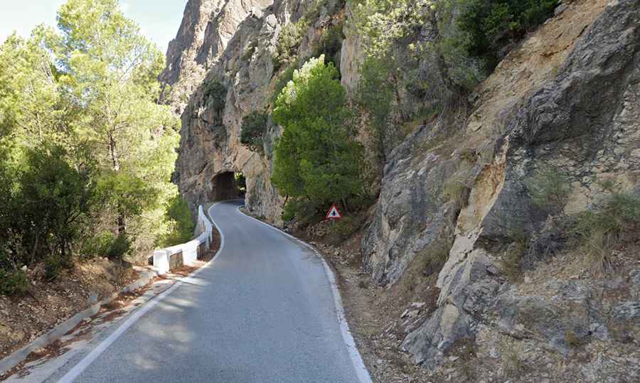
The drive is challenging, particularly on the northern approach from Quesada. The road twists through deep ravines, hitting maximum ramps of 16% on the tightest switchbacks. The most critical point of the drive is a single-lane tunnel blasted directly into the solid rock near the summit. This tunnel is blind, extremely narrow, and forces drivers to slow down to a crawl to check for oncoming traffic. Despite the sharp curves, the road remains open to all vehicles, meaning you may occasionally encounter slow-moving agricultural trucks on the narrowest bends.
How long is Puerto de Tíscar?
The complete mountain drive covers 30.3 km (18.8 miles) running from Quesada down to Pozo Alcón. The true mountain pass section is concentrated in the central 12 kilometers, where the road rapidly gains altitude. Completing the entire drive requires around 45 minutes due to the constant gear changes required by the steep slopes and the need to negotiate blind mountain corners safely.
Is the drive through Puerto de Tíscar worth it?
Located within the borders of the Parque Natural de las Sierras de Cazorla, Segura y Las Villas, the route offers stark contrasts. The Quesada slope is tightly enclosed by dramatic limestone walls and pine forests, which gradually open up into vast valleys filled with rolling olive groves as the road descends toward the south.
When is the best time to drive through Puerto de Tíscar?
Summer afternoons in this part of Jaén are brutal, with temperatures regularly exceeding 40°C, putting heavy thermal stress on car cooling systems during the steep 16% climbs. Conversely, winter can bring occasional snowfalls and ice patches in the shaded mountain corners. Spring and autumn offer the safest driving conditions on this quiet, low-traffic mountain route.
Road suggested by: jorge manuel gómez sánchez