Driving the steep Road to Pico el Puntal
Pico el Puntal is a prominent mountain peak reaching an elevation of 1,286m (4,219ft) above sea level, located in the Almería province of Andalusia, southern Spain. The summit is situated within the Sierra Alhamilla Natural Park, bordering the Tabernas Desert, which is known as the driest and warmest region in the country.
| Road facts: Pico el Puntal | |
|---|---|
| Location | Almería, Spain |
| Length | 14.9 km (9.2 miles) |
| Elevation Gain | 985 m |
| Avg. Gradient | 6.6% |
| Surface | Poorly paved / Broken asphalt |
| Hazard Level | High (Potholes & Steep ramps) |
Is the Road to Pico el Puntal paved?
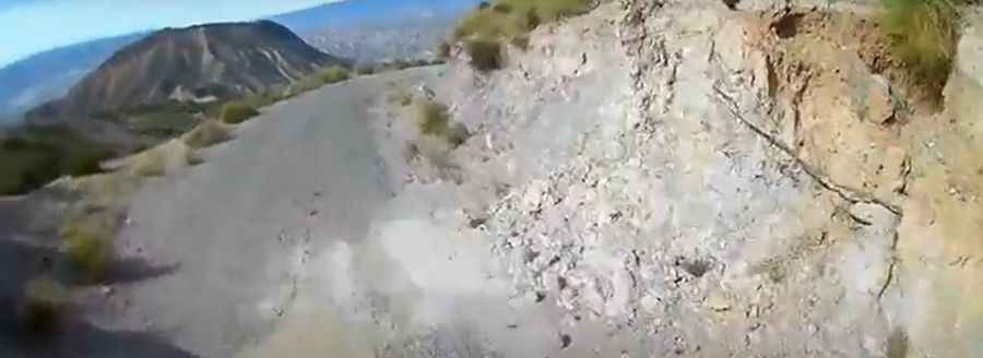
The Road to the summit was originally paved years ago, but its current condition is extremely poor. The surface has deteriorated significantly, becoming almost unpaved in several sections due to numerous potholes and erosion. Because of these surface conditions and the presence of narrow stretches with dangerous drop-offs, a high-clearance vehicle or SUV is highly recommended to complete the drive safely.
How long is the Road to Pico el Puntal?
Starting from the junction with the N-340a road near Oasis Mini Hollywood, the Road to the summit is 14.9 km (9.2 miles) long. This route takes drivers through a desert environment that has served as a filming location for iconic movies like The Good, the Bad and the Ugly and Conan the Barbarian. As the Road gains height, it offers expansive views over the Tabernas Desert before ending at the communication towers located at the peak.
What is the gradient of the Road to Pico el Puntal?
The climb is demanding, with a total elevation gain of 985 meters and an average gradient of 6.6%. However, the drive features several ramps that are much steeper than the average, requiring consistent engine power and careful traction management on the degraded surface.
Road suggested by: jorge manuel gómez sánchez
Pic&video: Carlos Liébana