Driving the intense and steep Pista de Chía in the Pyrenees
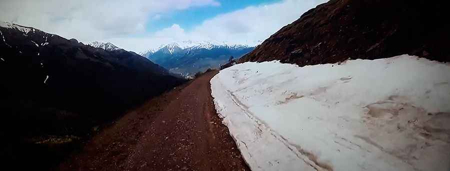
Pista de Chía is a high mountain road reaching an elevation of 2,028 meters (6,653 ft) above sea level in the Huesca province of Aragon, Spain. Connecting the villages of Chía and Plan, this track is a brutal link between the Benasque and Gistain valleys. This isn't a route for casual touring; it’s a high-consequence mountain drive where the asphalt gives way to loose gravel and steep concrete ramps. Driving here means managing your vehicle through 24.1 kilometers of unrelenting vertical gain, where the thin air and the narrow ledge sections demand a high-clearance vehicle and a driver prepared for the raw reality of the Pyrenees.
| Road facts: Pista de Chía | |
|---|---|
| Location | Huesca, Aragon, Spain |
| Elevation | 2,028m (6,653ft) |
| Length | 24.1 km (14.97 miles) |
| Max Gradient | 25% |
How difficult is the Pista de Chía drive?
The 24.1-kilometer journey is a technical challenge that combines high-altitude logistics with raw off-road driving. While some sections are covered in concrete to provide grip on the steepest inclines, most of the road is unpaved and littered with loose gravel. The climb features 20 hairpin turns that are exceptionally tight, requiring precision steering to avoid sliding on the debris. The most critical factor is the gradient; some ramps hit a staggering 25%, forcing even powerful SUVs to crawl in low gears. If you are driving a loaded vehicle, the strain on the transmission and the cooling system is constant as you fight for traction on the shifting surface.
What are the main hazards near Collado de Sahún?
The primary hazard at the Collado de Sahún and the surrounding Chia mountain range is the risk of rock slides and sudden weather shifts. The road is carved into steep slopes where the geology is unstable; heavy rain can quickly lead to landslides that narrow the track or block it entirely. Furthermore, the west side of the pass faces north, meaning it acts as a natural freezer. Ice patches and deep snow can linger well into June, turning the narrow ledge sections into a lethal trap. Fog is also a high-frequency event in this part of the Pyrenees, reducing visibility to a few meters and making the uncountable twists and turns even more technical.
Is the Pista de Chía open year-round?
No. The road is impassable during the winter months. Due to the high altitude of 2,028 meters and the north-facing orientation of the western slopes, snow accumulation is massive. Maintenance works are non-existent during the cold season, and the road only opens once the natural snowmelt allows, which can be as late as early summer. Trying to push through in May can result in getting your vehicle high-centered on a snowbank in a remote sector where recovery furgonetas are hours away. Always check the local conditions in Chía or Plan before attempting the full transit.
What mechanical prep is needed for the 25% gradients?
Before leaving Chía, verify that your cooling system is in top condition. Climbing 25% ramps on an unpaved surface means your motor is working at maximum load with very little airflow reaching the radiator. High-clearance vehicles are mandatory to avoid catching your underbody on the jagged rocks and deep ruts. On the descent toward Plan, do not ride your brakes. The sustained steepness will smoke your pads and boil your fluid within minutes. Use engine braking and stay in low range to maintain control. Carry at least 10 liters of extra water, a full-sized spare tire, and recovery gear, as a mechanical failure at 2,000 meters in this isolated part of Aragon is a serious survival situation.