What are the 18 Official National Tourist Routes of Norway?
Norway has 18 carefully selected scenic drives both in terms of nature/panorama and in terms of road construction itself, showcasing the country's best scenery. They have been designated National Tourist Routes. These routes are unique drives through the most spectacular countryside Norway has to offer.
What are the National Tourist Routes of Norway?
These roads are part of the national road system and will take you through the most beautiful scenery in Norway, going through some of the wildest and most beautiful scenery. Ten of them are located in Western Norway. By car or motorbike, a tour of Norway's most attractive tourist roads will take you across fjords and to views of breath-taking scenery as you drive for miles and miles through unspoiled countryside. Discover modern architecture and experience inspiring fjord, mountain and coastal scenery by driving one of Norway's 18 National Tourist Routes.
Varanger National Tourist Route
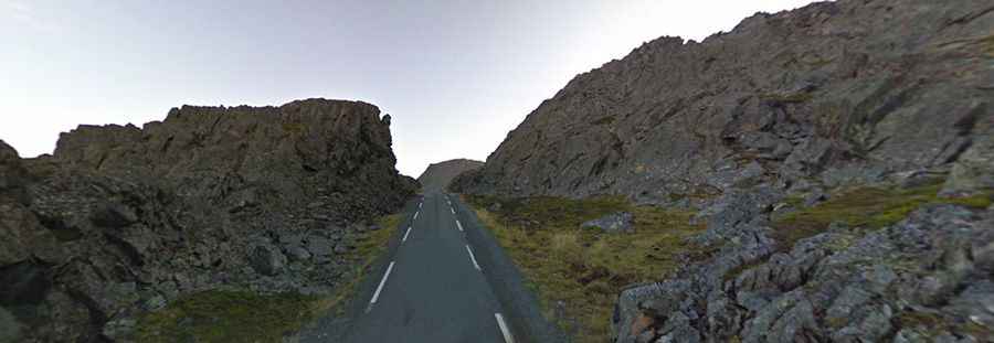
Get a taste of the far north in this less travelled corner of Norway. Rich birdlife, history and long summer nights lit by the midnight sun all await. Varanger National Tourist Route is a 160-kilometre-long stretch of road between Varangerbotn and Hamningberg in the county of Finnmark in Arctic Norway.
| Roads: Road 75/341 | Length: 160km | Elevation: 123m asl |
| Ferries: 0 | Winter notice: Hamningbergveien between Smelror and Hamningberg is closed during the winter. | |
Havøysund National Tourist Route
The road to Havøysund follows the ocean’s edge in wild and barren terrain towards the far north of Norway and its enticing Arctic light. Havøysund National Tourist Route is a 85-kilometre-long stretch of road between Kokelv and Havøysund in the county of Finnmark in Northern Norway.
| Roads: Road 889 | Length: 85km | Elevation: 233m asl |
| Ferries: 0 | Winter notice: Open to traffic throughout the year. May be closed for short periods in winter when the weather is bad. | |
Senja National Tourist Route
Discover the striking scenery of the outer coast of the Island of Senja in Northern Norway, which reaches out into the mighty Norwegian Sea. Senja National Tourist Route is a 90-kilometre-long stretch of road between Gryllefjord and Botnhamn on the island Senja in the county of Troms in Northern Norway. In addition, the official route includes detours to Mefjordvær and Husøya, for an additional 12 kilometres of road.
| Roads: Road 86/862 | Length: 102km | Elevation: 287m asl |
| Ferries: 0 | Winter notice: Open to traffic throughout the year. May be closed for short periods in winter when the weather is bad. | |
Andøya National Tourist Route
Enjoy a scenic drive on Vesterålen in Northern Norway. This coastal road on AndøyaIsland is characterised by the open sea and long, white beaches. Andøya National Tourist Route is a 58-kilometre-long stretch of road between Andenes and Bjørnskinn in the Vesterålen Archipelago in the county of Nordland in Northern Norway.
| Roads: Road 974/976/82 | Length: 58km | Elevation: 65m asl |
| Ferries: 0 | Winter notice: Open to traffic throughout the year. May be closed for short periods in winter when the weather is bad. | |
Lofoten National Tourist Route
Discover the beauty of the LofotenIslands, anchored above the Arctic Circle, by driving from Raftsundet to Å - one of Norway's most scenic routes. The Lofoten National Tourist Route in the county of Nordland is a 230-kilometre-long stretch of road between the bridge across Raftsundet in the north of the islands and Å in the south.
| Roads: E10 and others | Length: 230km | Elevation: 59m asl |
| Ferries: 0 | Winter notice: Open to traffic throughout the year. May be closed for short periods in winter when the weather is bad. | |
Helgeland Coast National Tourist Route
Experience the cultural heritage of Northern Norway and its many natural wonders, from the majestic Svartisen Glacier to the VegaIslands. Helgeland Coast National Tourist Route in the county of Nordland runs between Holm and Godøystraumen and is 433 kilometres long.
| Roads: Road 17, 76, 54 | Length: 433km | Elevation: 346m asl |
| Ferries: 6 | Winter notice: Open to traffic throughout the year. May be closed for short periods in winter when the weather is bad. | |
The Atlantic Road
Sharp turns and wild nature have put the Atlantic Road at the top of the British newspaper The Guardian's list of the world's best road trips. The Atlantic Road is a 8-kilometre long stretch of road between the towns of Kristiansund and Molde.
| Roads: 64, 242, 663... | Length: 36km | Elevation: 30m asl |
| Ferries: 0 | Winter notice: Open to traffic throughout the year. May be closed for short periods in winter when the weather is bad. | |
Geiranger - Trollstigen National Tourist Route
Experience the UNESCO-protected Geirangerfjord and the Trollstigen Mountain Road, two of Norway's most dramatic and most visited attractions. Geiranger - Trollstigen National Tourist Route is a 104-kilometre-long stretch of road between Lake Langvatnet and the Sogge Bridge.
| Roads: Road 63 | Length: 104km | Elevation: 1.038m asl |
| Ferries: 1 | Winter notice: Langvatnet to Geiranger closed Nov-May. Trollstigen closed Oct-May. | |
Rondane National Tourist Route
A peaceful drive on Fv27 between Sollia Church and Folldal is an excellent alternative to the main routes through Gudbrandsdalen and Østerdalen. Rondane National Tourist Route is a 75-kilometre-long stretch of road running from Muen and Sollia Church to Folldal.
| Roads: Road 27/219 | Length: 75km | Elevation: 1.060m asl |
| Ferries: 0 | Winter notice: Open to traffic throughout the year. May be closed for short periods in winter. | |
The Old Strynefjell National Tourist Route
Completed in 1894, the Old Strynefjell mountain road was a masterpiece of road-building and engineering. The Old Strynefjell Mountain Road (Gamle Strynefjellsveien) is a 27-kilometre long stretch of road between Videseter and Grotli.
| Roads: Road 258 | Length: 27km | Elevation: 1.139m |
| Ferries: 0 | Winter notice: Normally closed in October and reopens in June. | |
Sognefjellet National Tourist Route
High in the Jotunheimen mountains, the Sognefjellet Mountain Road runs between the Sognefjord and the Gudbrandsdalen Valley. It is the highest mountain pass in Northern Europe.
| Roads: Road 55 | Length: 108km | Elevation: 1.434m asl |
| Ferries: 0 | Winter notice: From Liasanden to Turtagrø is normally closed Nov-May. | |
Gaularfjellet National Tourist Route
The road over Gaularfjellet takes travellers past many waterfalls along the mighty Sognefjord. Gaularfjellet National Tourist Route is a 114-kilometre-long stretch of road between Balestrand, Moskog and Sande.
| Roads: Road 55/13/610 | Length: 114km | Elevation: 784m asl |
| Ferries: 0 | Winter notice: The road over Gaularfjellet is closed during winter from Mel to Mjell. | |
Aurlandsfjellet National Tourist Route
The road over Aurlandsfjellet is a journey across a barren plateau through a desolate landscape of snow and rocks. Aurlandsfjellet National Tourist Route is a 49-kilometre-long stretch between Aurlandsvangen and Lærdal.
| Roads: Road 243 | Length: 47km | Elevation: 1.306m |
| Ferries: 0 | Winter notice: Closed over the mountain during the winter season. | |
Valdresflye National Tourist Route
The road across Valdresflye provides endless vistas of rolling hills and steep mountains. Valdresflye National Tourist Route is a 49-kilometre-long stretch of road between Garli and Hindsæter.
| Roads: Road 51 | Length: 49km | Elevation: 1.389m |
| Ferries: 0 | Winter notice: Parts of the route are closed during the winter between Garli and Maurvangen. | |
Hardangervidda National Tourist Route
Drive through Hardangervidda National Park and over Northern Europe's largest mountain plateau. Hardangervidda National Tourist Route is a 67-kilometre-long stretch between Eidfjord and Haugastøl.
| Roads: Road 7 | Length: 67km | Elevation: 1.250m asl |
| Ferries: 0 | Winter notice: Open year-round. May be closed for short periods in winter. | |
Hardanger National Tourist Route
Follow the scenic Hardangerfjord in Fjord Norway, where travellers come to see mountains, fjords and waterfalls. The Hardanger National Tourist Route is a 158-kilometre-long stretch east of Bergen.
| Roads: 7, 49, 550, 13 | Length: 158km | Elevation: 275m asl |
| Ferries: 2 | Winter notice: Open year-round. May be closed for short periods in winter. | |
Ryfylke National Tourist Route
In Ryfylke, green skerries and cultural landscapes are suddenly replaced by mountains and fjords. Ryfylke National Tourist Route is a 260-kilometre-long stretch between Oanes and Hordalia in Røldal.
| Roads: Road 520, Road 13 | Length: 260km | Elevation: 972m asl |
| Ferries: 2 | Winter notice: From Helandsbygd to Røldal is normally closed Nov-June. | |
Jæren National Tourist Route
Jæren offers open skies, wide horizons and endless ocean. Mile upon mile of sandy beaches and sand dunes. Jæren National Tourist Route is a 41-kilometre-long stretch of road between Ogna and Bore.
| Roads: Road 44/507 | Length: 41km | Elevation: 35m asl |
| Ferries: 0 | Winter notice: Open year-round. May be closed for short periods in winter. | |
More info: http://www.visitnorway.com/en/what-to-do/tours-safaris/tour-suggestions/follow-a-national-tourist-route/