'The Road' is the main road on the island of Saba
Located on the tiny Dutch Caribbean island of Saba, The Road is an engineering marvel. It’s the main road of the island and runs from the airport to the harbor, passing through all four villages on the island. Its construction was led by Josephus Lambert Hassell, who believed a road could be built despite doubts from Dutch and Swiss engineers.
How long is 'The Road' on the island of Saba?
The road is 10.6 km (6.58 miles) long. It’s made of concrete and goes from the airport, through Hell’s Gate, Windwardside, St. John, and The Bottom, which are Saba’s four villages.
When was Saba's Main Road built?
The road is known locally as "The Road that Couldn't Be Built" because people once believed it was impossible to build a road on Saba Island. Civil engineer Josephus Lambert Hassell, a resident of the island, along with the Saban people, began building the road in 1938 without using any machines. The first section of the road was inaugurated in 1943, and by 1958, the road was finished.
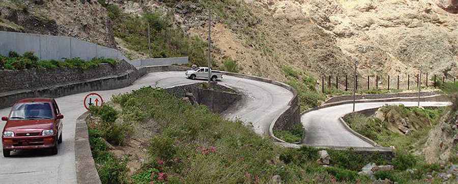
How challenging is 'The Road' in Saba?
The road is narrow, with several sections impassable for two cars at the same time. Driving "The Road" is a unique experience. It's normal to feel nervous looking at photos of the road; imagine what it must have been like before the barriers. The road includes very steep sections because the island is basically one big volcano with steep hills and slopes on all sides, climbing over 1,200 feet in less than a mile. The curves in Windwardside are particularly difficult to navigate.
Is the drive through 'The Road' worth it?
Driving is on the right-hand side. As you wind and twist along the cliff sides, you may struggle to focus on the amazing views of neighboring islands, villages, and varied seascapes. The road passes through different ecological zones, from dry tundra to dense tropical vegetation, with many steep drop-offs along the way. The views are spectacular. The highest point of the road, which is over 1,800 ft above sea level, is at the end of the "Mountain Road" near the Mt. Scenery trail. So don't be surprised if you transition from bright sunshine to cool clouds while driving on Saba.
Road suggested by: sebas van hemert
Pic: Eveline de Vree http://www.sabatourism.com/sabasroad.html