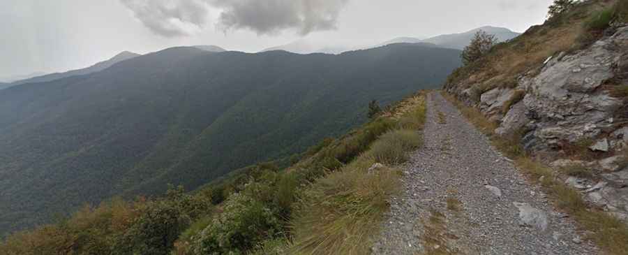
How to drive the gravel road to Col de Muraton?
Col de Muraton, also known as Passo del Muratone, is an international mountain pass at an elevation of 1,163 meters (3,815 ft) above sea level, located on the border between France (Alpes-Maritimes) and Italy (Liguria). The 16.4 km mountain route links the Italian town of Pigna with the French border crest. Originally a rough mule track, the current road is entirely unpaved, forming a narrow gravel ledge carved directly into the steep slopes of the Ligurian Alps.
| Road facts: Col de Muraton / Passo del Muratone | |
|---|---|
| Location | France-Italy Border (Ligurian Alps) |
| Elevation | 1,163 m (3,815 ft) |
| Length | 16.4 km (10.2 miles) from Pigna |
| Surface | Unpaved (Coarse gravel, loose stones, and dirt) |
| Key Features | 19 sharp hairpin turns with zero outer guardrails |
What are the driving challenges of the 16.4 km Muraton climb?
The climb from the SP64 road near Pigna to the summit crest covers 16.4 km of continuous unpaved track. The route is a rough, bumpy ride that forces a slow pace across 19 sharp hairpin turns. The hardest driving sector is found on the upper part of the mountain, where the track crosses the nearby Colle Scarassan. A high-clearance 4x4 vehicle is required to climb the steeper switchbacks. The track is narrow, and the outer edges have zero steel guardrails or concrete barriers.
How to drive the gravel surface and narrow shelf sections?
Because the Passo del Muratone follows the footprint of an old military mule track, the roadbed is poor. The surface consists of raw earth and loose river stones that shift under the weight of the vehicle, making braking unpredictable. The track is littered with sharp limestone shards. On the narrowest balcony sections, the lane is less than 3 meters wide, leaving zero room for two vehicles to pass each other. Drivers must watch the road ahead to spot the few natural rock wide spots to pull over before hitting the tight final ramps.
What are the hazards of the Muraton-Scarassan sector?
The combined track over Col de Muraton and Colle Scarassan runs along exposed mountain walls where high-altitude weather changes can drop visibility to zero in minutes. The unpaved route has no built-in concrete drainage grids, meaning heavy rain storms wash out the dirt foundation and leave deep, sharp gullies across the lane. Jagged rocks protrude directly from the track bed, presenting a constant risk of smashing unshielded oil pans or cracking transmission housings. The only spot to safely turn a large vehicle around is the small, unpaved clearing located right at the 1,163-meter summit line.
What is the seasonal status of the Pigna-Muraton road?
Heavy winter snowpacks and autumn mudslides regularly close the pass from late November until late April. This remote border track receives zero winter maintenance or snowplow service, leaving the mountain isolated for months. During the open summer and autumn seasons, the primary danger shifts to rockfalls, as the vertical shale cliffs above the road drop loose stones directly onto the driving lane after every storm.