How to drive the unpaved road to Croce di Lazfons?
Croce di Lazfons is a high mountain peak at an elevation of 2.316m (7,598ft) above sea level, located in the Autonomous Province of Bolzano – South Tyrol of Italy.
Where is Croce di Lazfons?
The peak is located in the Trentino-Alto Adige region, in the northern part of the country.
Why is there a road to Croce di Lazfons?
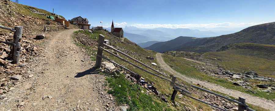
At the summit there’s a mountain hut called Rifugio Santa Croce di Lazfons-Schutzhaus Latzfonserkreuz and a pilgrimage chapel known as Chiesetta Santa Croce di Lazfons. It’s said to be the highest pilgrimage church in Europe.
Is the road to Croce di Lazfons unpaved?
The road to the summit is totally unpaved, very steep, with narrow parts. 4x4 vehicles only. The drive is curvy, with 12 hairpin turns.
How long is the road to Croce di Lazfons?
Starting from Latzfons, the road to the summit is 10.4 km long. Over this distance, the elevation gain is 1,143 m and the average gradient is 10.99%.
Can I drive the road to Croce di Lazfons?
Motorized vehicle traffic is strictly prohibited by municipal law and blocked by a gate, leaving the track reserved exclusively for the 4x4 vehicles of local ranchers, tractors hauling supplies up to the mountain hut, and emergency services.
Is the road to Croce di Lazfons open year-round?
Set high in the Alpi Sarentine, the road is totally impassable in winters due to the heavy snowfalls in the area.
Pic: Olaf Pötter