Basera Pass: Driving the historic military border between Italy and France
Reaching an elevation of 2,040m (6,692ft) above sea level, Passo de Basèra (or Basera Pass) is an international high mountain pass situated directly on the frontier between France and Italy. This high-altitude crossing is part of the legendary network of former military tracks in the Maritime Alps, offering a journey through a landscape where history and rugged nature collide.
| Road facts: Basera Pass | |
|---|---|
| Location | Italy-France Border (Piedmont / Alpes-Maritimes) |
| Elevation | 2,040 m (6,692 ft) |
| Length | 1.2 km (0.75 miles) |
| Road Type | Old Military Track (Unpaved) |
| Hazard Level | Moderate (Loose rocks & Cliffs) |
Where is Basera Pass?
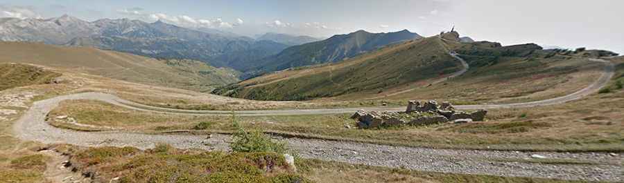
The pass is located on the ridgeline of the Alps, linking the Province of Cuneo in the Italian region of Piedmont with the Alpes-Maritimes department in southeastern France. This area was a major defensive line during the early 20th century. Along the road, drivers can spot the ruins of numerous military fortresses and artillery batteries that were part of the "Vallo Alpino" and the "Ligne Maginot Alpine." The pass sits in a strategic position, providing 360-degree views that stretch towards the Mediterranean coast on clear days.
Is the road to Basera Pass unpaved?
Yes, the road to the summit is totally unpaved. It is an old military route that has been preserved for off-road enthusiasts and hikers. While the track is technically open to all motorized vehicles, it is strongly recommended for high-clearance, 4-wheel drive vehicles. The surface is composed of loose stones and crushed rock, which can be slippery after rainfall. The road is narrow and often runs along steep mountain slopes without guardrails, so a "head for heights" and precise steering are required to navigate the passage safely.
How long is the road to Basera Pass?
Starting from the famous Passo di Tanarello, the road to Basera Pass is 1.2 km (0.75 miles) long. Although the distance is short, it is a high-intensity stretch that requires a slow pace due to the rocky nature of the terrain. The track follows the natural contour of the ridge, and because of its elevation above 2,000 meters, it is usually only passable from late June to October. During the rest of the year, deep snow and ice make the old military track completely impassable and extremely dangerous. Mechanical preparation is key, as the remote location means there is no help available in case of a breakdown.