How to drive the military track to Barbacana Pass?
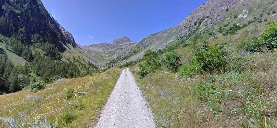
The Barbacana Pass (Passo di Barbacana) is an international high mountain crossing at an elevation of 2,180m (7,152ft) above sea level, located in the Alpes-Maritimes on the border between Italy (Piedmont) and France. The Italian side is accessed via an old unpaved military road starting from San Bernolfo. Logistically, the pass is a dead-end for motor vehicles; while the Italian side is a technical 4x4 track, the French side consists strictly of a walking path, making a cross-border transit impossible.
| Road facts: Barbacana Pass | |
|---|---|
| Location | Italy (San Bernolfo) - France Border |
| Elevation | 2,180m (7,152ft) |
| Length | 4.3 km (from San Bernolfo) |
| Average Gradient | 11.39% |
| Max Gradient | 15% |
What is the road condition of the Barbacana Pass track?
The 4.3 km ascent from San Bernolfo (Province of Cuneo) is a steep, unpaved military road with a sustained average gradient of 11.39%. The surface is composed of loose stones and native soil, which becomes highly unstable in wet conditions. During or after rain, the track turns into a muddy corridor with significantly reduced traction, requiring a 4x4 vehicle with high-torque capacity. Some sections feature gradients peaking at 15%, where picking a clean line is essential to avoid wheel spin on the uneven roadbed. The track is narrow and lacks guardrails, with significant exposure to the valley floor.
What are the technical logistics of the Barbacana Pass ascent?
Reaching the 2,180m summit involves a rapid elevation gain of 490 meters over a very short distance. This puts a massive load on the vehicle’s transmission and cooling system. Low-range gearing is a technical requirement to maintain control on the 15% ramps and to ensure effective engine braking during the descent. Logistically, the summit is marked by an abandoned military fortress. There is no room for large convoys to turn around easily, so any mission must be planned with small, agile high-clearance vehicles. The road is impassable during the winter months and often stays blocked by snow patches until late June.
How to manage weather safety on Barbacana Pass?
The weather in the Alpes-Maritimes is prone to sudden changes. Low clouds can settle on the Barbacana Pass ridge, reducing visibility to zero on a track that is already narrow and technical. It is a safety protocol to check the Piedmont regional weather forecast before leaving San Bernolfo. In case of a breakdown, the isolation of the upper valley means that mechanical recovery will be slow and expensive. Self-sufficiency is mandatory; carry basic recovery gear, including traction mats and a shovel, as the soft soil on the steeper sections can easily bog down a vehicle if momentum is lost.
Which vehicle preparation is required for Barbacana Pass?
A high-clearance 4x4 with A/T (All-Terrain) tires is the minimum requirement for the Barbacana track. Before starting the 4.3 km climb, ensure your tire sidewalls are intact, as the sharp rocks on the old military roadbed are a frequent cause of punctures. Verify your brake fluid levels and pad wear; the sustained 11% descent will generate significant heat. Logistically, ensure you have sufficient fuel before leaving the Cuneo valley, as consumption will spike on the high-gradient climb. Carrying a full-size spare tire and a high-lift jack is essential for any autonomous transit to the border ridge.