Skihaus Schöneben: Driving the High Road in South Tyrol
Located in South Tyrol, northern Italy, Skihaus Schöneben sits at an elevation of 2,105m (6,906ft). It is a high-altitude mountain hut near the border where Italy, Switzerland, and Austria meet. The road serves the Schöneben ski resort and offers a steep, technical climb through the mountains above the Reschenpass.
| Road facts: Skihaus Schöneben | |
|---|---|
| Location | South Tyrol, Italy |
| Hut Elevation | 2,105 m (6,906 ft) |
| Highest Point (Track) | 2,379 m (7,805 ft) |
| Length | 7.6 km (4.7 miles) |
| Surface | Asphalt / Gravel at the top |
How is the drive to Skihaus Schöneben?
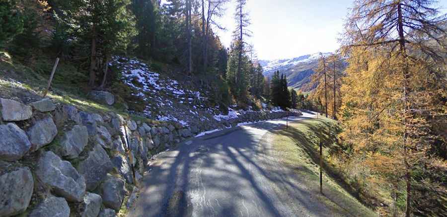
The road starts in St. Valentin auf der Haide (San Valentino alla Muta) and runs for 7.6 km to reach the hut. While the main road to the refuge is paved with asphalt, it is very narrow and steep. You’ll be dealing with several tight hairpins and constant gradients that will test your brakes on the way back down. Because of the altitude and the location, the road can be closed at any time if it snows, even outside of the peak winter season.
What about the road above the refuge?
Once you reach the Skihaus at 2,105m, the asphalt ends. There is a secondary gravel road that continues to climb through the ski resort, reaching a maximum elevation of 2,379m. This upper section is much rougher and is primarily used by service vehicles. If you plan to go higher than the hut, you’ll need a 4x4 with decent clearance, as the gravel can be loose and the track is unprotected with steep drops off the side.
Driving risks and seasonal access
The main hazard on this route is the lack of space. In many sections, the road is only wide enough for one vehicle, so you have to be ready to back up to a passing pocket if you meet someone coming down. In winter, the road is often restricted to ski resort traffic or completely buried under snow. Even in summer, mountain weather changes fast; a sudden storm can make the upper gravel track slippery and dangerous. Always check the local forecast in the Venosta Valley before heading up.
Logistics and Equipment
Make sure your vehicle's cooling system is in good shape before starting the 7.6 km climb—it’s a short but intense ascent. There are no fuel stations on the mountain, so fill up down in the valley. If you are driving a larger van or a camper, be extremely careful on the hairpins, as the narrow turns don't leave much room for error. The road is unlit and has no safety barriers on the highest sections.