La Riposa Refuge: Driving the 11% Grade to Pizzini in Lombardy
At an elevation of 2,706m (8,877ft) above sea level, La Riposa Refuge (locally known as Rifugio Pizzini-Frattola) is a high mountain hut located in the Lombardy region of Italy. Positioned at the head of the Cedec Valley, it is reached via one of the highest roads in the country.
| Road facts: La Riposa Refuge (Pizzini) | |
|---|---|
| Location | Province of Sondrio, Italy |
| Elevation | 2,706 m (8,877 ft) |
| Length | 4.4 km (2.73 miles) |
| Elevation Gain | 520 meters |
| Avg Gradient | 11.81% |
How is the road to La Riposa Refuge?
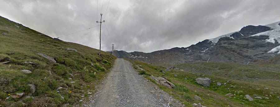
Starting from I Forni, the road to the refuge is 4.4 km (2.73 miles) long. The track is totally unpaved, exceptionally narrow, and features a sustained average gradient of 11.81%. This is a technical mountain ascent that gains 520 meters in a very short distance, requiring 4x4 vehicles with low-range gearing. The surface consists of loose glacial gravel and high-altitude scree. Beyond the hut, a secondary 4x4 trail continues climbing to Laghi di Cedèc, reaching 2,833m (9,294ft).
Access restrictions in the Stelvio National Park
Set high in the Parco Nazionale dello Stelvio, the road is subject to strict environmental regulations. Motorized transit is generally restricted to authorized vehicles only, such as mountain rescue, park staff, and the refuge's shuttle services. For authorized drivers, the road is typically open from mid-June through mid-September. During the rest of the year, heavy snow and avalanche risks in the Cedec Valley make the track completely impassable for wheeled traffic.
What are the main hazards on the Pizzini track?
The primary hazards are extreme gradients and lack of passing space. The 11.81% incline puts significant stress on the engine's cooling system in the thin air above 2,500 meters. On the descent, heavy engine braking is mandatory to prevent brake failure. The road is carved into the mountainside with steep unprotected drops and no safety barriers. Additionally, the track is shared with numerous hikers and mountain bikers, requiring extreme caution on the blind corners and narrowest segments where reversing may be necessary to allow others to pass.
History and Logistics of the Refuge
The original structure, Capanna Cedeh, was built in 1887 but was destroyed during the Great War. Rebuilt in 1926 and dedicated to Luigi E. Pizzini, the site has undergone several renovations, most recently in 2002. Today, the "Pizzini-Frattola" serves as a critical logistics hub for mountaineers. There are no fuel stations or mechanical services beyond Santa Caterina Valfurva. Authorized drivers must ensure they have sufficient fuel and a full-size spare tire, as the sharp rocks of the Ortler-Cevedale group are notorious for causing punctures.