Driving the steep road to Bruncu Spina: the roof of Sardinia
Bruncu Spina is a high mountain pass at an elevation of 1,828m (5,997ft) above sea level, located in the Gennargentu Range of Sardinia, Italy. It is the second-highest peak on the island and offers one of the most rugged and isolated driving experiences in the Mediterranean, ending at a derelict weather station with panoramic views.
| Road facts: Bruncu Spina | |
|---|---|
| Location | Nuoro Province, Sardinia, Italy |
| Length | 11 km (6.8 miles) |
| Max Elevation | 1,828 m (5,997 ft) |
| Max Gradient | 11.6% |
| Surface | Broken asphalt and gravel |
How challenging is the road to Bruncu Spina?
The climb to the summit starts from the SP7 road and stretches for 11 km, gaining 707 meters of vertical elevation. With an average gradient of 6.42%, the road is deceptively demanding, featuring specific ramps that hit a punishing 11.6%. The drive is characterized by its narrow width and the poor state of the pavement. The asphalt is heavily weathered, filled with cracks and potholes that require constant vigilance to avoid damaging the vehicle's rims or suspension. The last 3.3 km of the ascent transition into a rough gravel track, making a high-clearance vehicle or a 4x4 highly recommended to reach the very top safely.
What are the hazards when driving in the Gennargentu?
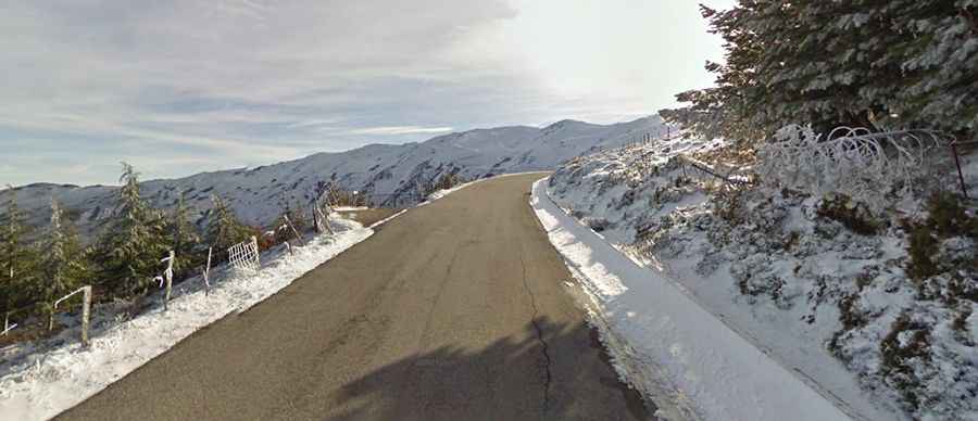
The primary hazard of Bruncu Spina is its exposed and unmaintained nature. In winter, this is one of the few places in Sardinia that receives heavy snowfall, turning the steep, narrow road into a lethal ice trap. Even in fair weather, the lack of modern safety barriers and the presence of loose stones on the broken asphalt can cause traction issues during the steepest climbs. The area is prone to sudden fog and high winds, which can reduce visibility to zero on the upper ridges. Drivers must also be alert for local livestock and wildlife that frequently roam the open mountain slopes without warning.
What awaits at the summit of Bruncu Spina?
Reaching the end of the road brings you to the remains of a ruined weather station and the base of the island's small ski lift system. The logistical isolation at 1,828 meters is absolute; there are no services, and the environment is stark and windswept. For those who brave the final gravel stretch, the reward is a 360-degree view of the Barbagia region and, on clear days, the distant Tyrrhenian Sea. It is a drive where mechanical sympathy is essential—pushing too hard on the broken surface will likely end in a mechanical failure far from the nearest service hub in Fonni.
How to prepare your vehicle for the climb?
Before attempting the ascent, ensure your cooling system and brakes are in top condition, as the 11.6% sections will put significant thermal stress on the engine and rotors. Given the sharp edges of the broken asphalt and the final gravel stage, check your tire pressure and ensure you carry a full-sized spare. This is not a high-speed transit; it is a slow, technical crawl to the roof of Sardinia where the focus should be on navigating the ruts and preserving the undercarriage from rock strikes.