Sella Sondogna: Driving the 30 Hairpins of the Dogna Valley
At an elevation of 1,392m (4,566ft) above sea level, Sella Sondogna (also known as Sella di Sompdogna or Siele Sompdogne) is a high mountain pass in the Province of Udine, Italy. Located in the Friuli-Venezia Giulia region, the road follows a strategic military route through the Julian Alps, connecting the Dogna Valley with the Val Saisera.
| Road facts: Sella Sondogna | |
|---|---|
| Location | Province of Udine, Italy |
| Elevation | 1,392 m (4,566 ft) |
| Length | 17.9 km (11.1 miles) |
| Hairpins | 30 |
| Surface | Fully Paved (Asphalt) |
How is the road to Sella Sondogna?
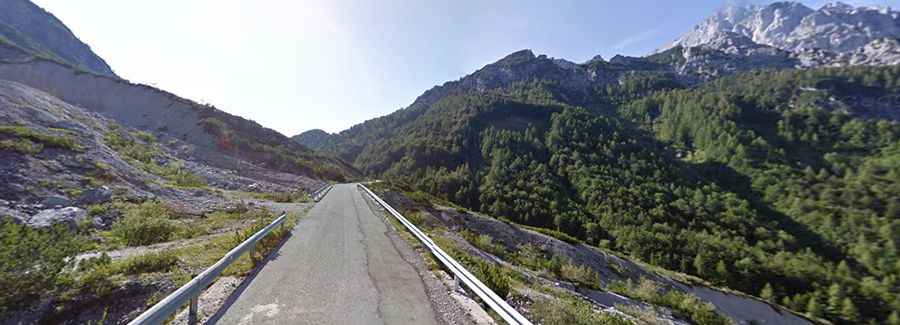
The drive starts from Porto and covers 17.9 km (11.1 miles) to reach the summit. While the road is fully paved, it is narrow and technically demanding. The asphalt is often weathered and lacks lane markings in several sections. The route features 30 sharp hairpin turns, multiple bridges, and narrow tunnels carved directly into the rock. The road follows the path of an old military supply line from the First World War, and many concrete remnants and fortifications are still visible along the higher reaches of the pass.
What are the main hazards on the Dogna route?
The primary hazards are the lack of passing space and the risk of rockfalls. The road is so narrow that in many sections, meeting an oncoming vehicle requires one driver to reverse to a wider shoulder. The tunnels are dark and unlit, so ensuring your vehicle's lighting system is functional is a priority. During the autumn, the road can become extremely slick due to wet leaves and damp conditions in the shaded forest areas. Despite being paved, the steep inclines and constant maneuvering put heavy stress on the braking system during the long descent back to Porto.
Is Sella Sondogna open year-round?
The road is typically blocked by snow and ice during the winter months. Because it is a secondary mountain route, snow clearing is not a priority, and the tunnels can accumulate dangerous ice flows. The best window for driving is from late May to October. Even in summer, mountain storms can cause debris to fall onto the asphalt, so caution is advised after heavy rain. Due to its narrowness and tight hairpins, this road is not suitable for large motorhomes or trailers.
Logistics and Technical Prep
There are no services, fuel, or mobile signal for large portions of the 17.9 km climb. Fill up your tank in the lower Tagliamento valley before starting the ascent. Because of the 30 hairpins and the narrowness of the bridges, drivers should maintain a slow pace and use the horn before entering blind corners or tunnels. Ensure your brakes are in perfect condition, as the descent back down the narrow shelf sections requires constant control to avoid overheating.