Monte Dubasso Ridge Road: Driving the Crest Track to Colle San Bartolomeo
The high-mountain ridge road linking Monte della Guardia, Monte Dubasso, and Colle San Bartolomeo di Ormea is a single-lane mountain track located in the Ligurian Alps, running along the border zone between Piedmont and Liguria, in Italy. This 11.4 km (7.1 miles) crest route connects two different sections of the SP216 road.
| Road facts: Monte Dubasso Ridge Road | |
|---|---|
| Location | Cuneo (Piedmont) - Imperia (Liguria) border, Italy |
| Length | 11.4 km (7.1 miles) between SP216 junctions |
| Max Elevation | 1,654 m (5,426 ft) at Monte della Guardia |
| Surface | Broken asphalt, rough dirt, and concrete patches |
| Width | Strictly single-lane (2.5 to 3 meters) |
How challenging is the drive to Monte Dubasso?
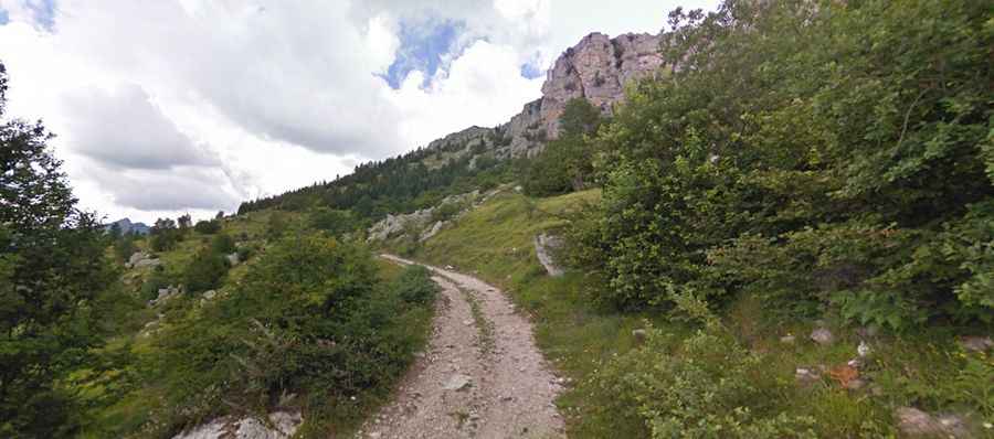
The 11.4 km track tracks the narrow mountain crest line with zero painted markings or outer safety barriers. The calçada is strictly single-vehicle wide, varying between 2.5 and 3 meters, which leaves no margin for error. Meeting oncoming traffic forces one vehicle to back up along sharp cliff edges for hundreds of meters until finding a wider dirt clearing or a natural rock turnout. The platform alternates constantly between fractured, potholed asphalt and coarse gravel sections that degrade quickly after winter transitions.
What are the main passes on the Monte della Guardia road?
The crest route rolls across three distinct high points along the alpine divide:
- Monte della Guardia: At 1,654 meters (5,426 ft), this is the highest altitude section of the track, sitting on a bare shale slope that drops steeply down to the Tanaro basin.
- Monte Dubasso: Reaching 1,538 meters (5,045 ft), the road here crosses open, wind-swept ridges where the track is exposed to lateral gusts and minor rockfalls from the upper crags.
- Colle San Bartolomeo di Ormea: Situated at 1,446 meters (4,744 ft), this lower pass functions as the southern connector where the track dips into a small grass clearing before rejoining the lower valley paths.
What should I keep in mind before driving the SP216 ridge?
The entire 11.4 km stretch is a remote mountain sector with zero fuel supply or mechanical workshops. Because the road runs directly between the inland valleys and the Mediterranean coast, sudden sea fog (locally called nebbia lupina) rolls over the ridge instantly, dropping driving visibility down to less than three meters on completely unprotected drops. Heavy summer rainstorms rapidly turn the unpaved dirt sections into slick mud fields, making front-wheel-drive cars slip on the steeper inclines.
Why is the Cappella di San Bartolomeo significant?
The small stone structure of Cappella di San Bartolomeo sits right at the mountain pass clearing at 1,446 meters. It serves as a physical checkpoint marking the old mule trail boundary between Piedmont and Liguria. The clearing around the chapel is very restricted, leaving barely enough room for one vehicle to turn around. Drivers stopping at this point must pull entirely off the main dirt track onto the grass to avoid blocking the single-lane thoroughfare for local forestry trucks or 4x4 vehicles.