Assietta Road: Driving the legendary military ridge track of the Western Alps
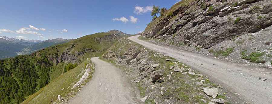
Strada dell'Assietta (SP173) is an unpaved military road running along the mountain ridge separating the Val Chisone and Val Susa in the Metropolitan City of Turin, Piedmont, in Italy. Connecting Sestriere to Pian dell’Alpe, the high-altitude track runs almost entirely above 2,000 meters elevation through the Gran Bosco di Salbertrand Park.
| Road facts: Strada dell'Assietta (SP173) | |
|---|---|
| Location | Sestriere to Pian dell'Alpe, Turin, Piedmont (Italy) |
| Length | 39.3 km (24.2 miles) |
| Highest Point | 2,615 m (8,579 ft) at Monte Gran Costa |
| Speed Limit | 30 km/h |
| Surface | Unpaved (Gravel, dirt, and loose rock) |
How long is the Assietta Road?
Designated as Strada Provinciale 173, the unpaved route spans 39.3 km (24.2 miles) along the alpine crest between Sauze d'Oulx and Colle delle Finestre. The single-lane dirt track follows open ridge lines for over 30 kilometers inside the protected boundaries of the Gran Bosco di Salbertrand Park.
When was the Assietta Road built?
Military commanders of the Kingdom of Italy commissioned the road in 1890 to enable the movement of troops and heavy artillery between the Chisone and Susa valleys. Meticulously planned by military combat engineers starting in 1889, the route retains visible military history along the ridge, including the ruins of Gran Costa fort, barracks, and defensive stone walls.
What passes does the Assietta Road cross?
The 39.3-kilometer ridge route links several continuous mountain passes, making it one of the highest roads in Italy:
Monte Gran Costa (2,615 m / 8,579 ft): The highest point of the entire SP173 route, positioned on an open ridge sector with steep drops into the valley.
Colle Lauson (2,497 m / 8,192 ft): A high pass connecting the upper valleys along a narrow dirt shelf road.
Colle dell'Assietta (2,472 m / 8,110 ft): The central focal point of the ridge, marked by military monuments and wide gravel plateau sections.
Colle Basset (2,424 m / 7,952 ft): Located near the Sestriere end of the route, connecting the ski slopes with the main ridge line.
Colle Blegier (2,381 m / 7,811 ft): A narrow dirt pass cutting along exposed mountain slopes with loose rock surface.
Colle di Costa Piana (2,313 m / 7,588 ft): An unpaved sector crossing open alpine meadows along the ridge.
Colle Bourget (2,299 m / 7,542 ft): A lower pass along the track featuring tight turns on broken rock and earth.
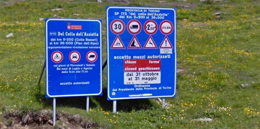
What are the driving rules and summer restrictions on the Assietta Road?
The SP173 is open to motorized vehicles from June 1st to October 31st, weather permitting. Vehicles are subject to strict limits: maximum weight of 3.5 tons, maximum width of 2 meters, and a 30 km/h speed limit. Overtaking and parking off the established roadbed are strictly prohibited.
During July and August, the road is closed to motorized traffic on Wednesdays and Saturdays from 9:00 AM to 5:00 PM, reserving the track exclusively for non-motorized users. For real-time updates on closures, it is recommended to check the official website at www.stradadellassietta.it.
What hazards exist on the Assietta Road?
The unpaved single-lane track lacks guardrails along steep cliff drops, using only low stone walls or natural edges. Heavy rain creates deep ruts, exposes sharp rocks, and causes mud on steep switchbacks. Meeting oncoming vehicles on narrow ledge sections requires using designated turnouts, while thick mountain fog frequently reduces visibility along the unlit ridge.