Assietta Road runs entirely above 2.000 meters in the western Alps
Strada dell'Assietta is a military carriageway along the ridge that connects Pian dell’Alpe to Sestriere, in the Metropolitan City of Turin, in northern Piedmont region of Italy.
How long is Assietta Road?
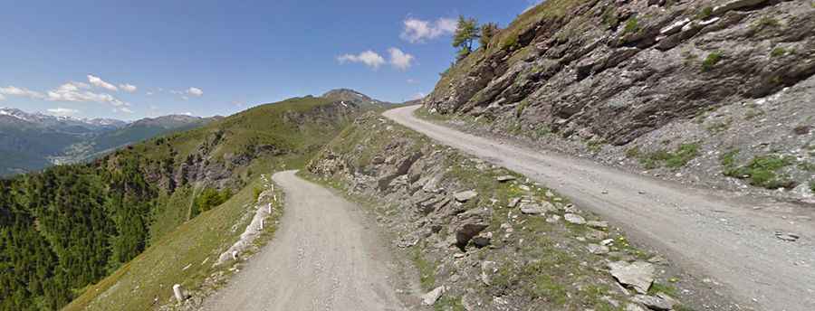
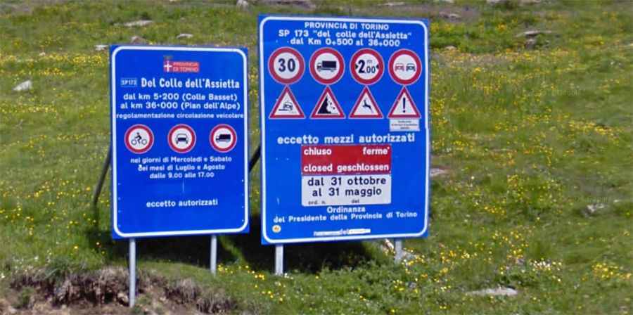
The road, Strada provinciale 173 del Colle dell'Assietta, is mostly unpaved. It’s 39.3 km (24.23 miles) long, running almost entirely over 2,000 meters above sea level. The road can be traveled in two ways. It runs from Sauze d'Oulx to Colle delle Finestre. The military road leads along the ridge connecting Pian dell'Alpe with Sestriere and separates Val Chisone from Val Susa. It develops for over 30 kilometers within Gran Bosco di Salbertrand Park and represents a unique opportunity to discover some of the most significant events in the history of this extremely fascinating place set in the western Alps.
When was Assietta Road built?
This road was built by Kingdom of Italy military commanders in 1890, with the aim of allowing quick troop movement from Chisone to Susa Valley. This project was realized in 1889, studied by combat engineers. The ruins of forts are still visible.
Is Assietta Road worth it?
The road offers sweeping views and a challenge for drivers. It is used by cyclists, bikers, on foot, and on horseback excursionists and motorized vehicles. It also offers the chance to understand a territory and the signs left by its people over the years. In order to enable proper and sensitive fruition of the users’ different needs, each person may promote “smooth,” slow, and respectful circulation. Traveling on the Assietta road offers a unique chance to discover some of the most significant historical landmarks of one of the most striking corners of the Western Alps. It’s an incredible historical, artistic, environmental, and recreational itinerary. The road is traveled each year by hundreds of passionate excursionists, bikers, cyclists, mainly coming from abroad (Germany), and recently, it is undergoing a development process directed to improve its usability.
Is Assietta Road open?
Set high in the western Alps, along the way, you’ll have to travel through eight mountain passes between 2,200m and 2,585m high. The road only opens from June 1st to October 31st, and transit is forbidden to vehicles over 3.5 tons weight and vehicles over 2 meters wide. The highest point on the ridge road is after the Assietta pass, and the lowest point is between Colle di Costa Piana and Colle Bourget, right in the middle. To get more information about the road and the closure days, see the www.stradadellassietta.it website. The road has recently undergone improvement to make it more usable and is closed to motor vehicles on Wednesdays and Saturdays in July and August.
It climbs up to:
-Colle dell'Assietta (2.474 m)
-Colle Lauson (2.497m)
-Colle Blegier (2.381 m)
-Colle di Costa Piana (2.313 m)
-Colle Bourget (2.299 m)
-Colle Basset (2.424 m)
Is Assietta Road difficult?
The road is not easy. It cuts along a cliff face where there is only a foot-high wall separating you and a sheer, base jumps wet dream, drop to the valley below. The road is totally drivable despite many rocks and a deteriorated surface, especially in curves. It has a speed limit of 30 km/h and is forbidden to overtake or stop outside the parking areas.