Driving Strada dei Cannoni, a military mountain road in Italy
Strada dei Cannoni is a legendary military road located in the northern part of Italy, running across the high watershed between the Maira and Varaita valleys. The road is a masterpiece of alpine engineering, climbing from 680m to 2,287m (7,503ft) above sea level through some of the most dramatic landscapes in the Province of Cuneo.
Is Strada dei Cannoni paved?
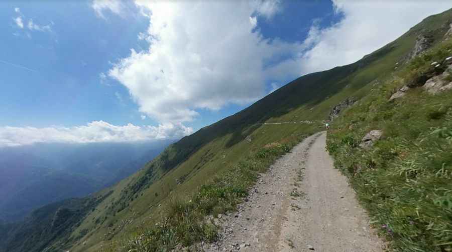
Set high in the northwestern part of the country, the road—also known as Varaita-Maira-Kammstraße—is mostly unpaved (75%). Originally designed for military purposes, it is today a fascinating journey for nature lovers. The area remains under military property, though it is recognized for its spectacular path that allows travelers to follow the ridge while enjoying magnificent views of the Maritime and Cottian Alps, dominated by the presence of Monviso.
The Route: Passes and High Points
Because the Strada dei Cannoni follows a long mountain ridge, it crowns several iconic passes. Each of these locations offers a unique perspective on the Piedmontese Alps:
How long is Strada dei Cannoni?
Running across the watershed between Valle Maira and Valle Varaita, the Road of the Cannons is 56km (34 miles) long. It runs from Colletta di Rossana (680m/2,230ft) in the territory of Busca to Colle della Bicocca in the Municipality of Elva at 2,287m (7,503ft).
Is Strada dei Cannoni open?
Access is strictly regulated during the peak season. According to local sources, from July to September, the road is closed to motor vehicles on Saturdays, Sundays, and public holidays from 09:00 to 18:00. At night, the road is also closed from 21:00 to 06:00. In winter, the route is usually impassable due to heavy snow.
Is Strada dei Cannoni challenging?
Unique, difficult, and hardly frequented, the drive is a real off-road adventure. The little-used route is partly in very poor condition and should only be tackled by experienced off-roaders in good weather conditions. Coarse gravel, tight hairpin bends, and steep inclines require full attention, as many sections feature unprotected drops of hundreds of meters.
History: The Ancient Road of the Piedmontese Army
This strategic pass was initially built by engineers of the Piedmontese army in 1744 to impede the Franco-Spanish advance during the War of the Austrian Succession. Commissioned by Carlo Emanuele III, the road aimed to provide a faster and safer passage over the Alps for troops.
Starting from Casteldelfino in the Varaita Valley, the original path led to the Sampeyre hill, descended to Stroppo, and continued through the Colle dell'Encucetta towards Demonte. Despite its impressive construction, the road was never utilized in battle due to the absence of fighting near Cuneo.
From Napoleon's Trail to Modern Remnants
Over time, parts of the road transitioned to civilian use. A segment of the trail, including a portion believed to be used by Napoleon's army, was once known as the "Route Napoleon." While this specific track has largely vanished, the road we know today was officially built in 1893 by the Army Corps of Engineers on the ridge between the two valleys.
Engineering Efforts and Modernization
The road underwent significant maintenance in 1938 to adapt the mule track for motorized transit. The project transformed it into a "Type C" road, with work completed in 1941 by the Sorge company using both military and civilian manpower.
In 2014, a two-kilometer stretch connecting provincial roads in Lemma and Valmala was paved, creating an ideal loop for cyclists. Today, the path remains dotted with obsolete military barracks, standing as silent remnants of its historical significance.
Pic: Renato Cane