Driving the Via del Sale: A High-Mountain 4x4 Road in the Ligurian Alps
The Via del Sale is a legendary military track winding through the crests of the Ligurian Alps, right on the border between Italy and France. Connecting Limone Piemonte to Monesi di Triora, this route is one of Europe’s most spectacular 4x4 challenges, with a high-altitude military history and demanding off-road driving.
| Road facts: Via del Sale | |
|---|---|
| Location | Ligurian Alps (Italy/France border) |
| Length | 30 km (18.6 miles) |
| Surface | Unpaved / Loose gravel / Rock |
| Max Altitude | 2,239 m (Colle di Perla) |
Where is the Via del Sale road?
This high-mountain track, also known as the Alta Via del Sale or Ligurische Grenzkammstrasse, is located in the Cuneo province, in the southwest of Italy's Piedmont region. Set high in the Maritime Alps, the road crosses back and forth over the French border. The road is famous for its situation, offering views that stretch from the snow-capped Alpine peaks all the way to the Ligurian Sea on clear days.
How long is Via del Sale?
The main section of the unpaved track covers approximately 30 kilometers (18.6 miles). Due to the rough terrain and narrow passes where yielding is required, you should expect to spend at least half a day or a full day to complete it safely. Even experienced drivers pushing the pace will need over 2 hours just to cover the distance without stops.
When was the Via del Sale road built?
The route’s name (Salt Road) dates back to the Middle Ages, when it was a vital trade route for transporting salt from the Mediterranean coast at Ventimiglia up to Turin. Later, its strategic military importance led to massive expansions. The road was widened and fortified to connect several mountain forts guarding the border. Today, the 19th-century engineering is still visible in the hand-carved tunnels and the dry-stone walls that keep the track clinging to the cliffs.
Is the Via del Sale road difficult to drive?
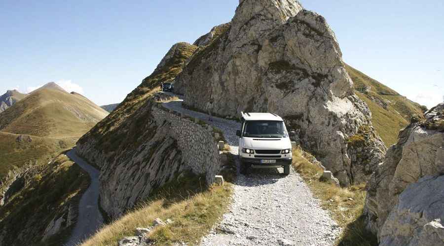
Driving here is a serious undertaking that requires a high-clearance 4x4 vehicle. The road is entirely unpaved, with loose gravel, sharp rocks, and steep climbs. Some sections have remnants of asphalt, but very deep holes make the route more challenging. It is a first-class off-road experience, but one that demands constant attention. Drivers must respect the weight limits often posted at the entrance of the Via del Sale, as these military-era mountain tracks are not designed for heavy modern vehicles. There are no gas stations or repair shops on the ridge, and mobile phone coverage is spotty at best. Ensure your vehicle has a full-size spare tire (repair kits are useless against sharp Alpine rocks) and plenty of water.
Key hazards to watch for:
- Dizzying Cliffs: Many sections have no guardrails, with vertical drops right at the edge of the tires.
- Tight Hairpins: Steep climbs combined with sharp turns require precise steering and low-range gears.
- Terrain Inspection: After heavy rains, parts of the track can wash away. It is often necessary to get out of the car and walk the path to inspect for stability before proceeding.
The road climbs through several iconic mountain passes:
- Passo della Guardia (1,508 m)
- Passo di Collardente-Pas de Colle Ardente (1,617m). Near the pass summit, the track runs through the Galleria di Collardente, an old, curved military tunnel carved directly into the raw rock face. The tunnel is completely unlit, narrow, and damp, with water constantly dripping from the unlined stone ceiling. Because of the curve, you cannot see oncoming headlights from the opposite entrance before entering.
- Colle di Perla (2,239 m)
- Colle de Carsene (2,221 m)
- Colle Malaberghe-Col de Malabergue (2,225 m)
- Passo di Tanarello-Pas du Tanarel (2,042 m)
- Col de la Boaire-Colle della Boaria (2,102 m)
- Colle del Lago dei Signori (2,130 m). The summit hosts a parking lot (Parcheggio Colle del Lago dei Signori) and a mountain hut known as Rifugio Don Barbera.
- Colle del Garezzo (1,795 m). The pass is traversed by a long unlit tunnel of 70 meters.
Is the Via del Sale road open?
The road is strictly seasonal. It is usually closed from October to late May due to heavy snow. Even in the summer, the track can be closed if access hasn't been cleared or after severe weather. Be prepared for sudden fog, which can reduce visibility to near zero in minutes, making the narrow cliff sections extremely dangerous.
Do I need to pay to drive the Via del Sale road?
Since 2019, the road has been regulated to preserve the environment and ensure safety. You must book your entry in advance at altaviadelsale.com. There is a fee of 15 EUR per vehicle, and the number of permits is strictly limited each day. Note that certain days are reserved exclusively for hikers and cyclists—motorized vehicles are prohibited on those specific dates.
Road suggested by: Michael Spannlang
More pics here