How to drive the steep 4x4 track to Colma di Marucolo?
Colma di Marucolo is a high mountain peak at an elevation of 1,857m (6,092ft) above sea level, located in the province of Brescia, Lombardy (Italy). Situated in the Prealps, the summit is occupied by a large communication tower. Logistically, the road to the peak is a technical continuation of the route starting from Colle San Zeno. The track is strictly unpaved and serves as an essential service road for telecommunications maintenance.
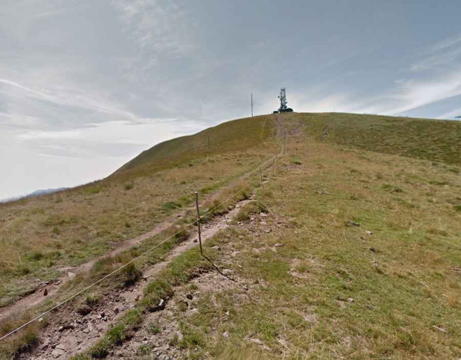
| Road facts: Colma di Marucolo | |
|---|---|
| Location | Brescia, Lombardy, Italy |
| Elevation | 1,857 m (6,092 ft) |
| Length | 3.8 km (2.36 miles) |
| Average Gradient | 11.39% |
| Technical Requirement | High-clearance 4x4 with Low Range |
What is the road condition from Colle San Zeno to Colma di Marucolo?
The 3.8 km ascent from Colle San Zeno is a high-stress driving operation. Technically, the road surface consists of a mix of soft earth, grass, and loose stones, deeply marked by parallel ruts. These ruts are often deep enough to pose a risk of high-centering for standard vehicles. The average gradient of 11.39%, combined with an elevation gain of 433 meters in such a short distance, requires constant torque management. Logistically, the track is only suitable for high-clearance 4x4 vehicles, particularly in wet conditions where the clay-based soil loses all frictional integrity.
How to navigate the deep ruts on the Colma di Marucolo track?
Driving to the 1,857m summit requires advanced off-road techniques. Technically, the presence of deep ruts means drivers must utilize the "straddling" technique—positioning tires on the higher center ridge and the outer edge of the track to maintain underbody clearance. Logistically, the 3.8 km transit is highly sensitive to weather; rain quickly turns the ruts into mud channels, making traction nearly impossible without specialized All-Terrain tires. The final approach to the communication tower involves even steeper ramps where the surface becomes more fractured and rocky.
Is the road to the Colma di Marucolo antenna open year-round?
Logistically, access to Colma di Marucolo is seasonal. While the lower Colle San Zeno may be accessible, the 3.8 km track to the peak is usually impassable from late autumn until the end of the spring thaw. Technically, there is no snow removal service on this branch road. Snowdrifts often accumulate in the ruts, creating hidden traps for 4x4s. Before attempting the climb, it is a mandatory safety protocol to verify local weather conditions in the Val Trompia sector, as the peak is completely exposed to high winds and rapid visibility changes that make navigating the narrow, rutted track extremely hazardous.
Vehicle requirements for the 11.39% average gradient climb
The technical profile of Colma di Marucolo demands a vehicle in perfect mechanical condition. The 11.39% average gradient puts extreme pressure on the transmission and cooling system. Logistically, a low-range transfer case is essential to control the vehicle during the descent back to Colle San Zeno, preventing brake overheating on the sustained 433m drop. Drivers must inspect their vehicle’s ground clearance and ensure that the differential housings are protected. Self-recovery equipment, such as traction mats or a winch, is a recommended logistical precaution due to the high probability of getting bogged down in the deep, grassy ruts during the 3.8 km transit.