Fleckner Hut: Driving the high mountain track in the Stubai Alps
Situated in the South Tyrol province of northern Italy, Flecknerhütte (Fleckner Hut) is a high mountain refuge at an elevation of 2,056m (6,745ft) above sea level. Located in the heart of the Stubai Alps, the road leading to the hut offers some of the most dramatic views over the Passeier Valley, though it remains a highly restricted and technical mountain track.
| Road facts: Fleckner Hut | |
|---|---|
| Location | South Tyrol, Italy (Stubai Alps) |
| Elevation | 2,056 m (6,745 ft) |
| Length | 1.2 km (0.74 miles) |
| Average Gradient | 6.33% |
| Access | Restricted / Service Road |
Where is Fleckner Hut?
The hut is perched high above the Passeier Valley (Val Passiria) in northern Italy. It sits in a prominent position within the Stubai Alps, a subrange of the Central Eastern Alps. The geographic location provides a unique vantage point between the deep valleys and the high glaciated peaks of the region. Most visitors access the area via the famous SS44, which is the main artery connecting the mountain communities of South Tyrol.
Is the road to Fleckner Hut unpaved?
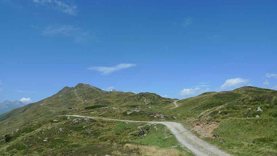
Yes, the road to the summit is entirely unpaved. The surface consists of compact gravel and loose stones, typical of Alpine service roads. It is an exceptionally narrow track with several steep sections that require careful maneuvering. It is important to note that the road is entirely closed to caravans and strictly closed to private motorized vehicles beyond the Parcheggio al Römerkehre (Parkplatz an der Römerkehre). Only authorized service vehicles and local agricultural transport are permitted to drive to the hut. For those on foot or with mountain bikes, the road represents a steady, technical climb through high-altitude meadows.
How long is the road to Fleckner Hut?
Starting from the junction with Strada Statale 44 (SS44), very close to the iconic Monte Giovo Pass (Jaufenpass), the road is 1.2 km (0.74 miles) long. Over this short distance, the elevation gain is 76 meters, with an average gradient of 6.33%. Despite the modest average, the track contains sharp ramps and hairpins that hug the mountainside. Beyond the hut itself, a tiny and even more rugged gravel road continues to climb, reaching an elevation of 2,158m (7,080ft) near the ridgeline.
Is the road to Fleckner Hut open?
Due to its high elevation in the Stubai Alps, the road to the hut is usually impassable in winter and remains covered in snow and ice for several months. During the summer season, while the gate restricts private traffic at the Römerkehre parking, the route is a popular path for hikers and experienced mountain bikers. The weather can change instantly at 2,000 meters; even in July, thick fog and cold winds are common. Before heading to this high-altitude area, always ensure you have checked the local weather forecast for the Passeier Valley and respect the local traffic regulations.
Pic: Пётр Климачёв