Monte Cengio Mule Track: A Journey Through Italy's Great War Legacy
The Mulattiera di Arroccamento al Monte Cengio is a spectacular Italian military track dating back to the Great War. Dominating the Val d'Astico in the Veneto region, this masterpiece of mountain engineering was built on vertical cliffs to supply men and materials to the bastion of Monte Cengio, the last line of defense for the Po Valley.
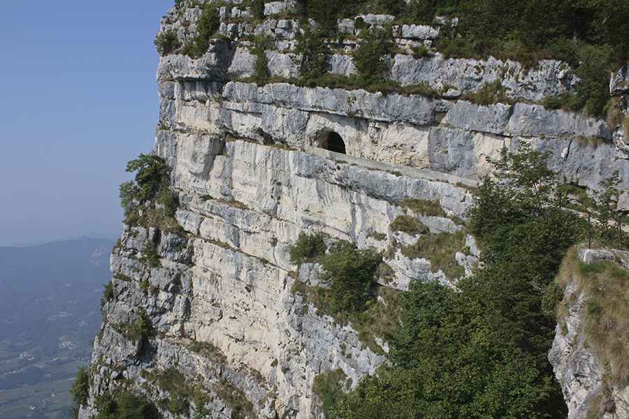
Known as the "Granatiera" in honor of the Grenadiers of Sardinia, the track is carved directly into the living rock. It utilizes natural ledges and a series of hand-cut tunnels to remain shielded from enemy fire. Today, it stands as a "Sacred Area to the Homeland," preserving the memory of the fierce battles fought in the Vicenza Pre-Alps between 1917 and 1918.
| Road facts: Monte Cengio (Granatiera) | |
|---|---|
| Location | Province of Vicenza, Veneto (Italy) |
| Elevation | 1,347 m (4,419 ft) |
| Length | 4 km (2.5 miles) |
| Type | Military Mule Track (Closed to Motor Vehicles) |
| Built | 1917–1918 |
When was the Monte Cengio military road built?
The track was constructed between 1917 and 1918 by the 93rd Sappers Company of the 1st Engineer Regiment. Its strategic purpose was to provide a secure ascent route from the Vicenza plain to the summit area, protected from Austro-Hungarian artillery fire from the north. The path connects the Val d'Astico to the Seven Municipalities plateau, serving as a vital logistical artery during the conflict. One of its most impressive features is the 187-meter-long main tunnel, which sits at an altitude of 1,351m and once housed a massive concrete water reservoir.
What is it like to travel the Monte Cengio Mule Track?
The journey along the southwest flank of the massif covers approximately 4 km of incredible cliff-side terrain. This "Grenadier Path" delved into the living rock, creating a sheltered gallery for soldiers. Today, hikers can explore the trenches, artillery emplacements, and the famous "Grenadiers' Jump" (Salto del Granatiere). While the road is completely closed to motor vehicles, it remains an essential destination for those interested in military engineering and history. The tunnels offer a refreshing break on hot days, and the entire route provides breathtaking views of the Astico Valley and the surrounding plains.
Can you access Monte Cengio by car?
While the historic mule track itself is a pedestrian-only heritage site, the general area of Monte Cengio is accessible via nearby paved mountain roads in the province of Vicenza. Visitors typically park near the Piazzale Principe di Piemonte to begin the historical walk. The path covers a 150m altitude difference to reach the 1,347m summit. It is a hauntingly beautiful route where the engineering of the Great War meets the natural majesty of the Italian Alps.
Image credit: Depositphotos