Road to Monte Tavolino: Driving the 19.73% Gradient in South Tyrol
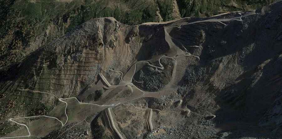
Monte Tavolino, also known as Sefiarspitze, is a high mountain peak at an elevation of 2,505 meters (8,218 ft) above sea level, located in South Tyrol, northern Italy. Situated within the Texel Group of the Ötztal Alps, the route leading to the summit is a raw, unpaved single-lane service track built for ski infrastructure maintenance.
| Road facts: Monte Tavolino (Sefiarspitze) | |
|---|---|
| Location | South Tyrol, Northern Italy |
| Elevation | 2,505 m (8,218 ft) |
| Length | 4.5 km (2.79 miles) from Pfelders |
| Average Gradient | 19.73% |
| Surface | Unpaved loose gravel and large embedded stones |
How brutal are the 19.7% gradients on the Monte Tavolino track?
The unpaved mountain route climbs for 4.5 kilometers starting from the alpine village of Pfelders (Plan). Over this distance, the track gains 888 vertical meters, ranking it among the steepest dirt tracks in the Texelgruppe Nature Park. The average slope is a brutal 19.73%, but the hardest sections feature sustained ramps that cross even higher gradients. The surface consists entirely of alpine gravel and large embedded boulders. Climbing these vertical walls requires a low-range four-wheel-drive system.
Why do wheels spin and slide on the Monte Tavolino hairpins?
The single-lane dirt track climbs the open mountain ridge through incredibly tight switchbacks. The inner radius of these hairpins is extremely steep, causing heavy axle articulation that lifts wheels off the ground. The surface in the curves is constantly broken up by water runoff and the weight of utility machinery, leaving deep loose stone piles and ruts. The lane is narrow, leaving zero space to maneuver or turn around. The route completely lacks steel guardrails or side embankments.
How does the alpine winter affect the Monte Tavolino road?
At an elevation of 2,505 meters, the track is blocked by heavy snowbanks and thick ice sheets for most of the year, keeping the route completely impassable outside the short summer window from June to September. Sudden afternoon mountain storms turn the dry gravel into a slick clay slurry in minutes.