Is Strada Statale 1 Via Aurelia (SS 1) worth the drive?
The Strada Statale 1 Via Aurelia (SS 1) is a historic trade route running along the Italian coastline from central Italy to southern France. Derived from the ancient Roman road built in 241 BC by Gaius Aurelius Cotta, it remains one of the most significant state highways in the country and a legendary route for drivers today.
| Road facts: SS1 Via Aurelia | |
|---|---|
| Location | Italy (Rome to Ventimiglia) |
| Length | 697 km (433 miles) |
| Max Elevation | 615 m (Bracco Pass) |
| Surface | Paved / Asphalt |
When Was Via Aurelia Built?
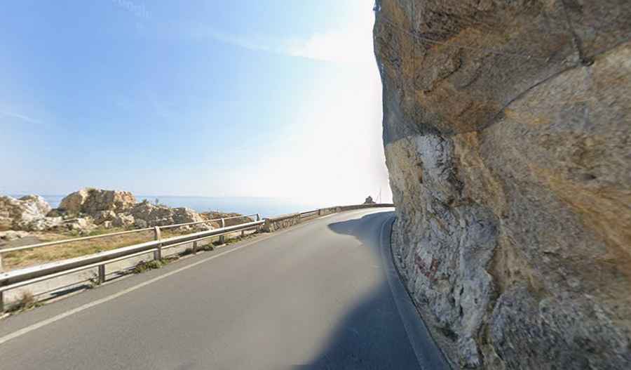
The road is extremely scenic and follows the original Via Aurelia, a Roman road constructed in 241 BC. It is one of the most important state highways in Italy. Along the way, you can still see sections where ancient stone walls are maintained next to modern metal barriers, keeping the road tucked against the mountain slopes.
Where Does Via Aurelia Start and End?
The road is completely paved and runs from Rome to Ventimiglia, near the French-Italian border on the Gulf of Genoa. It follows the silhouette of the beach, crossing small seaside villages and offering access to beautiful coves. The drive is a cycling icon; the Milan-San Remo race passes through here, on sections where the road is literally carved into the rock face.
How Long is Via Aurelia?
The road is 697 km (433 miles) long, running through nine provincial capitals. It is usually very crowded with tourists during holidays. It’s a slow drive where the sea breeze often pushes the car around, and you have to be patient with the constant flow of vans and local traffic.
What’s the highest part of Strada Statale 1 Via Aurelia (SS 1)?
Leaving La Spezia, the Aurelia climbs toward a mountain pass (Foce), then descends through Riccò del Golfo di Spezia to the Vara valley. It then rises to the Bracco Pass (615 meters), the highest point of the route. After crossing the hills of Moneglia, you face 15 very winding kilometers downhill to Sestri Levante. With many tight bends, it is perfect for nimble cars with less power—think Lotus and you will understand. It’s popular with motorcycles and cyclists on weekends, so pay attention. Also, make sure to stop at the classic cafe in Mattarana after the pass; it's a favorite local stop.
Is Strada Statale 1 Via Aurelia (SS 1) Worth the Drive?
The most scenic stretch runs from Genoa to the French border. However, be careful: some traffic lights are specifically there to turn red if sensors detect rockfalls on the road. In many corners, the center line disappears, and there is almost no space to pull over if you have a breakdown. If you stop for an emergency, you will likely block the entire narrow path.
Strada Statale 1 Via Aurelia vs Autostrada dei Fiori: Who wins?
The SS1 is the old-school road that runs right along the sea, full of tight bends where you’re almost touching the water. The Autostrada dei Fiori (A10) sits higher up on viaducts and is the better bet if you want to avoid turning around in the narrow streets of towns like Noli. But for the real driving experience, the SS1 is where it's at.
Road suggested by: Michael Spannlang