Driving the demanding Road F35 in the Highlands of Iceland
F35 is a challenging gravel road in Iceland, running at an elevation of about 600–700 meters, from north to south, through Kjölur, a plateau in the country's highlands.
How long is Route 35 in Iceland?
The road (also known as the Kjalvegur Road and Kjölur Route) is 168km (104mi) long, stretching from the south of Iceland near Haukadalur, behind the Gullfoss waterfall, to the north near Blönduós.
Is Route 35 Iceland paved?
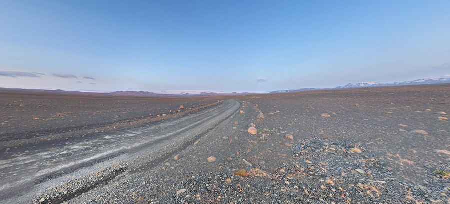
It’s a corrugated and tuff gravel road and the second longest of the roads through the Highlands of Iceland. The majority of the route is flat. The drive has a long history, once being a vital horse trail, allowing trade routes through the land.
Is the Kjölur Route (F35) difficult?
It’s one of the famous F Roads of the country. F roads in Iceland are only open in the summer around June to the end of August/September and the Kjölur is no different. These roads are mountainous and dangerous. They are unpaved, have unpredictable and fast-changing weather areas, and are usually well above sea level. They require a 4WD, and your insurance would not cover you if you were to drive on one with a 2WD. The road is often tough to drive and usually not maintained to standards, so a 4x4 vehicle is required. However, river crossings along the way are bridged. In the summer months it’s possible to drive it in almost any car. Not, however, recommended using low vehicles. Due to its special character as an unsealed road, it is not undertaken lightly. Driving this road is most certainly an amazing experience, but not every car can venture on it. It runs through the geographical area, in which passenger rental cars are not allowed. For many years the road possessed a dark reputation for being dangerous and haunted. Not only you'll need a 4WD for an F road but you will need significant ground clearance because there are often moments where you will have to cross deep water and rivers in the vehicle.
Does the Kjölur Route (F35) cross any river?
The F35 has some difficult patches, but doesn’t have any official river crossings. It is a good idea to get information on the weather conditions of that exact day, on the day, as you pass through, however. If you venture slightly off to another F road (easily done), it’s worth bearing in mind that rivers from glaciers can get deeper over the course of several hours, so it’s a good idea to watch other vehicles travel through first (there can be significantly high amounts of water). It is also a good idea to drive downstream if it’s possible (with the current) and drive very slowly. Only the first portion of the F35 (Blöndulón) is a good road, which you can drive at highway speed. After this, the road deteriorates into gravel and big rocks and you will want to reduce your speed significantly - in fact, the speed limit changes to 40km/h. There is not a lot of traffic, although a few cars are always a good reference point to help you drive safely. Many sections of the F35 will actually require first gear - under 10km/h speeds. Only towards the very end will the roads become proper again.
Is the Kjölur Route (F35) open?
It’s one of the highest roads of the country, topping out at 672m (2,204ft) above sea level. Access is seasonal. It’s only open from the end of June until the middle of September. In the winter it is covered with snow. Expect cold temperatures and rapidly changing weather patterns. It requires planning your trip in advance.
How long to drive F35 Iceland?
To drive the road without stopping will take most people between 5 and 6 hours. The route leads through the middle of Iceland. It is enjoyable with a magnificent view of glaciers, mountains, and highland lakes. It’s said to be the most famous road of the Icelandic highlands. If you like scenic drives, then this route is definitely for you. The road traverses the interior between two glaciers, Langjökull and Hofsjökull.
Is the F35 in Iceland worth it?
Along the way, there are some incredible places to stop by. There are plenty of walking trails and natural wonders so it is worth exploring. There needs to be a high degree of caution, however. Its altitude is partly the cause of its exclusivity - for most of the year, it is decimated by snow and unpredictable snow storms. Given how carefully you have to drive along this dangerous road, you will most certainly not make it across in a single day. Because of this, you’ll want to make the most of your surroundings, of which it has many natural wonders and places to grab some food. There is some interesting cuisine to be tried at the restaurants in Iceland. Hveravellir for example is around a third of the way down the F35 and has two camping houses. This tiny, remote place has a quaint restaurant along with a swimming pool and hiking opportunities. From here you can see the Langjökull glaciers, the Kerlingarfjöll and the Kjalhraun lava field. Hveravellir also has natural hot springs. In fact, it is known for its fire and ice combination as the water boils up from the earth and flows both cold and hot. Kerlingarfjöll is along the F35 route too (around half way), which is certainly a place you will want to slow down and take a look around. It is only 10km off the F35 via the F347, where there is 100 km2 area of mountains that stretch over 1.5km tall. This is a popular spot for photographers as there’s usually snow at the top of the mountains still as well as some hot springs and vegetation crops that have an incredible color palette. There are plenty of campsites, although Iceland is incredibly liberal in its wild camping laws. This can be a chance to jump into some geothermal pools and see the Gýgjarfoss waterfall.
Pic: Fabien Roucoux