Driving the shelf road from Kontogianni to Chelidona
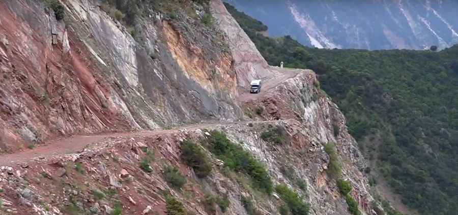
Located in the Evrytania regional unit of central Greece, the road from Kontogianni to Chelidona is a very challenging trip. Following the path of the Rema Krikeliotis river, this 7.1 km (4.4 miles) route is one of the most dangerous roads in the country due to its extreme exposure and precarious engineering.
| Road facts: Kontogianni to Chelidona | |
|---|---|
| Location | Evrytania, Central Greece |
| Length | 7.1 km (4.4 miles) |
| Surface | Partial Asphalt / Loose Gravel |
| Hazards | Vertical drops / No guardrails |
How challenging is the road from Kontogianni to Chelidona?
The road is 7.1 km (4.4 miles) long. It’s a shelf road carved directly into the steep slopes of the Evrytania mountains. The road is exceptionally narrow, leaving zero margin for error when encountering oncoming traffic. The most hazardous sector involves driving along unprotected cliffs with vertical drops exceeding 300 meters (1,000 feet). The absence of guardrails and the constant risk of landslides make this trip suitable only for experienced drivers with high tolerance for extreme vertigo.
What are the driving conditions on the Kontogianni-Chelidona route?
The road surface is inconsistent, transitioning from deteriorating asphalt to loose gravel sections near the end of the 7.1 km stretch. The surface is subject to severe lateral erosion, where the outer edge of the track crumbles toward the Rema Krikeliotis river valley. Drivers must account for the unstable rock walls on the inner side, which frequently drop debris onto the path. Passing maneuvers are impossible in several sections, requiring one vehicle to reverse for long distances along the cliff edge to find a slightly wider bypass.
Is the road to Chelidona safe for large vehicles?
Driving the Kontogianni-Chelidona road in a large vehicle or motorhome is not recommended. The combination of steep grades, sharp unmarked turns, and the narrow shelf-like geometry of the track makes it extremely difficult for vehicles with a long wheelbase. It is not a regional transit for general traffic, and the route should be avoided during heavy rain or wind, as the instability of the red-soil cliffs increases the risk of road collapse.
Pic&video: Bas Brand