A drive to the legendary Mount Kaliakouda
Mount Kaliakouda is a high mountain pass at an elevation of 1,741m (5,711ft) above sea level, located in the Evrytania region of Greece. It's one of the highest roads in the country.
Where is Mount Kaliakouda?
The pass is located in the southern Pindus Mountains, in the central region of the country.
Is the road to Mount Kaliakouda unpaved?
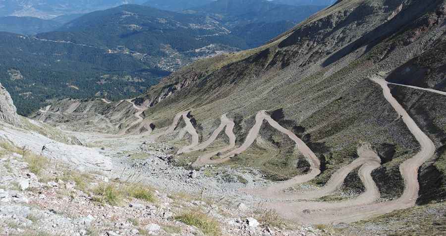
The road to the summit is not for the faint-hearted. It’s totally unpaved and not recommended if you’re prone to car sickness, with more than 70 hairpin turns. The road is rocky and looks solid, but the flowing waters create difficult passages; you will probably find holes on the track and fallen rocks, so drive with caution. The road has irreversibly damaged the local environment, while landslides are not a rare phenomenon.
How long is the road through Kaliakouda Pass?
The pass is 15.0 km (9.32 miles) long, running north-south from Aniada to Stournara.
How long does it take to drive through Kaliakouda Pass?
To drive the road without stopping will take most people between 1 and 1.5 hours. The summit hosts a mountain shelter. The region served as a base for resistance fighters during WWII.
Is Mount Kaliakouda open?
The road is usually open all year round, but it can be closed at any time when the access is not cleared of snow. Snow lies on the slope and does not melt before August.
¡Pic: Παντελής Γ.