How to drive the steep gravel track to Ostlerhütte?
The Ostlerhütte is an alpine mountain hut at an elevation of 1,797m (5,895ft) above sea level, located in the Ostallgäu district of Bavaria, Germany, within the Allgäu Alps and near the Austrian border. The access is a high-altitude gravel road that serves as a logistical supply route. Although it is one of the highest roads in Germany, it is closed to private motor vehicles, and transit is restricted to authorized personnel and emergency services using 4x4 equipment.
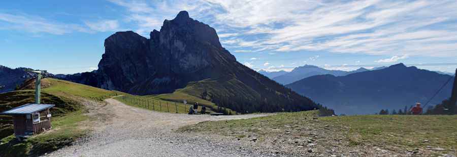
| Road facts: Ostlerhütte | |
|---|---|
| Location | Germany (Bavaria) - Allgäu Alps |
| Elevation | 1,797m (5,895ft) |
| Length | 6.6 km (from Achtalstraße) |
| Average Gradient | 11.4% |
| Access | Restricted / Authorized 4x4 only |
What are the driving hazards on the 11.4% climb to Ostlerhütte?
The 6.6 km ascent from Achtalstraße involves a 753-meter elevation gain. The resulting average gradient of 11.4% is exceptionally steep for a gravel surface. Under these conditions, maintaining constant momentum is a technical requirement to avoid wheel spin on the loose stones. The track features tight hairpins where the inner radius can exceed 15%, requiring high-torque delivery from the drivetrain. The road is narrow and lacks guardrails, with vertical exposure in several sectors of the Pfrontener valley ridge.
What are the mechanical requirements for the Ostlerhütte supply track?
A high-clearance 4x4 with a functional low-range transfer case is necessary to manage the 11.4% incline without overstressing the transmission. On the descent back to the valley, the sustained gradient creates a high risk of brake overheating. It is a mandatory safety protocol to use engine braking in a low gear to control the vehicle's speed. Logistically, the summit at 1,797m has limited space for maneuvering, so only compact or medium-sized utility vehicles can execute turns safely near the hut's foundations.
How to manage weather and traction in the Allgäu Alps?
The weather in the Ostallgäu district is highly volatile. Heavy rain can turn the gravel surface into a slippery mud-and-rock mixture, drastically reducing the friction coefficient. Visibility is frequently compromised by low clouds and fog. During the winter season, the 6.6 km track is completely impassable due to deep snow accumulation and is often used as a winter hiking or sledging path. Before any authorized transit, verify the local meteorological reports, as sudden storms can cause localized washouts that require high ground clearance to navigate safely.
Vehicle preparation for high-altitude Bavarian tracks
For any authorized mission to Ostlerhütte, the vehicle must be equipped with All-Terrain (A/T) tires in good condition to bite into the steep gravel. Before starting the 6.6 km climb, verify the braking system's fluid levels and pad wear. Logistically, Pfronten is the last point for fuel and mechanical support. It is a technical requirement to carry basic recovery gear, including traction mats and a shovel, as the soft shoulders of the alpine track can easily trap a vehicle if the driving line is lost during the 11.4% ascent.
Pic: Alexis Alexokratis