Is the road to Col de Peyrefitte in the Pyrenees paved?
Col de Peyrefitte, also known as Port de Pierrefite, is a high mountain pass at an elevation of 1,859m (6,099ft) above sea level on the border between the Haute-Garonne and Hautes-Pyrénées departments. This remote crossing in southwestern France is a journey through a road in transition; what was once a fully paved route is now a mix of decaying asphalt and rough gravel, reflecting years of exposure to the harsh Pyrenean climate and minimal maintenance.
| Road facts: Col de Peyrefitte | |
|---|---|
| Location | Haute-Garonne / Hautes-Pyrénées (France) |
| Elevation | 1,859m (6,099ft) |
| Road Name | Access via D51D |
| Length | 3.2 km (1.98 miles) |
| Surface | Decaying Asphalt / Gravel / Dirt |
How long is the road to Col de Peyrefitte?
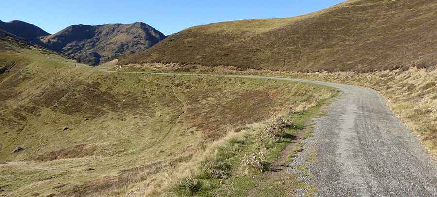
The final ascent to the pass begins at the junction with the D51D road and covers a short distance of 3.2 km (1.98 miles). Over this stretch, you gain 119 meters in elevation, maintaining an easy average gradient of 3.71%. While the incline is gentle compared to other Pyrenean giants, the difficulty lies in the surface. The track follows the ridge line, offering no protection from the elements, and the short distance can feel much longer due to the constant need to pick the cleanest line between the remaining patches of pavement and the encroaching dirt.
What is the road surface like at Port de Pierrefite?
The surface of the road to Col de Peyrefitte is in a state of advanced deterioration. As seen on the ground, the original asphalt has largely disintegrated near the summit, leaving behind a rough, grey gravel track with occasional bits of broken pavement. In the final sections, it is essentially an unpaved road. For cyclists, especially those on road bikes, this means navigating loose stones and potholes that can easily cause a puncture. For motorized traffic, the uneven ground requires low speeds to avoid damaging the undercarriage on the larger rocks that have surfaced over time.
Is the road to Col de Peyrefitte open to cars?
Access to the summit is strictly limited. While the road is technically open throughout the year, it is frequently blocked for cars by a physical barrier or gate. This restriction makes it a sanctuary for hikers and cyclists who can easily pass the barrier. If you are attempting to reach the pass in a vehicle, expect to find the way closed unless you have specific authorization. In winter, the gate is irrelevant as the high altitude means the road is buried under deep snow, making it completely impassable for any wheeled transport until the late spring thaw.
What are the hazards when crossing Col de Peyrefitte?
The main hazard on this pass is the exposure to weather and the lack of road integrity. At 1,859 meters, the ridge is subject to sudden fog and high winds that can make visibility difficult on the open slopes. Because the road is semi-abandoned for motorized use, there is a risk of small rockfalls and debris cluttering the track after heavy rain. The transition between the paved D51D and the crumbling sections of the pass can be jarring; drivers and riders must be wary of sharp edges where the asphalt has broken off, as these can easily slice through a tire sidewall.
Pic: http://randonnees-pyrenees-64.fr/2015/10/25/lac-de-bareilles-a-1760-metres-daltitude-en-vallee-du-louron-au-dessus-de-bourg-doueil-hautes-garonne/