Driving Route des Cols des Pyrenees with 34 remarkable mountain passes
Set high in the French Pyrenees, Route des Cols des Pyrénées is a very exciting journey through the Pyrenees from the Atlantic to the Mediterranean, crossing 34 remarkable mountain passes, with an elevation gain of 15,937 meters.
What’s Route des Cols des Pyrenees?
The drive is scattered over all 6 French departments of the Pyrenees (half of the route is in the Midi-Pyrénées region) through 34 remarkable mountain passes, many of which have been featured as highlights in the legendary Tour de France.
When was Route des Cols des Pyrenees created?
The route was created in the 19th century under the leadership of Emperor Napoleon III and his wife Eugénie. It was known as ‘The thermal route’ because this route linked many Pyrenean spa towns that were very popular amongst the leisured classes.
How long is Route des Cols des Pyrenees?
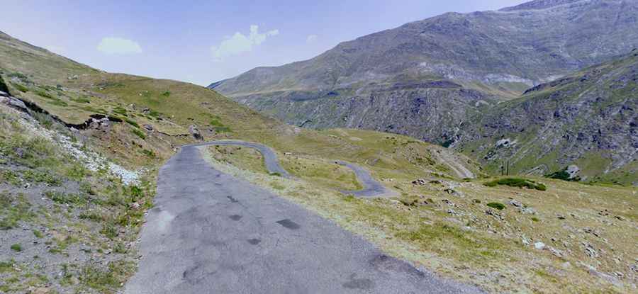
The drive is 942 km (585 miles) long, and it’s entirely paved. From pass to pass, valley after valley, the road allows you to discover by a posted mountain route many panoramic landscapes of the Pyrenees.
Is Route des Cols des Pyrenees worth it?
The journey offers ice, snow, Atlantic storms, flash floods, rock slides, fast drivers, and free-range cattle, horses, and deer. The experience is incredible: the landscapes and mountains can change quite dramatically from the Mediterranean side to the Atlantic side. Language, food, and culture also change from Mediterranean France through to the Occitan and Basque regions, making the route a voyage of discovery.
Main mountain passes from West to East:
| Col de Saint-Ignace | Col d'Aspin | Col de Marmare |
| Col d'Otxondo | Col d'Azet | Col des Sept Frères |
| Col d'Ispéguy | Col de Peyresourde | Col de Coudons |
| Col de Burdincurutcheta | Col du Portillon | Col du Portel |
| Col Bagargui | Col de Menté | Col de la Quillane |
| Col du Soudet | Col de Portet-d'Aspet | Col de la Perche |
| Col de Labays | Col de la Core | Col du Fourtou |
| Col d'Ichère | Col de Latrape | Col Xatard |
| Col de Marie-Blanque | Col d'Agnes | Col de Ternère |
| Col d'Aubisque | Port de Lers | Col de Mollo |
| Col du Soulor | Pas de Soulombrie | |
| Col du Tourmalet | Col du Chioula |
Is Route des Cols des Pyrenees open?
The Route des Cols also gives direct access to many remote and unmissable high mountain border crossings such as Col du Pierre St Martin, Port Larrau, and Col du Pourtalet as well as the incredible Cirque de Gavarnie and the insane road up to Cirque de Troumouse. Take note, however, the higher passes like Tourmalet and Aubisque are often closed by snow from late October through to mid-June. And as always in any mountainous region bad weather even in summer can make many of the cols along the route highly dangerous from snow to flash floods. When touring in this region between April to mid-June, it's highly recommended to check out the weather each morning for your day's route as the risk of flash floods at lower altitudes and rapid temperature drops due to Atlantic storms should not be underestimated.
Top Tip for Route des Cols des Pyrenees
If the weather in the French Pyrenees is a washout, simply crossing the border into Spain just a short distance to the south (20-30 km) you'll more often than not find a dramatic weather change for the better with blue skies and blinding sun.
Road suggested by: www.RoadTrooper.com
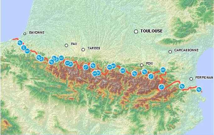
Map by: Par Assemblée Pyrénéenne d'Economie Montagnarde (APEM) - http://www.apem.asso.fr/ repsonsable du développement du site http://www.laroutedescols.com/ — http://www.laroutedescols.com/pages/index.php?m1=M_RDC&m2=M_RCART, CC BY 2.5, https://commons.wikimedia.org/w/index.php?curid=2178404