Driving to Pic de Chabrières: A brutal 2.701m 4x4 track in the Queyras Alps
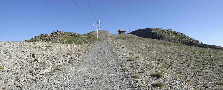
Located in the Hautes-Alpes department of southeastern France, the track to Pic de Chabrières is a high-altitude monster that pushes the limits of off-road driving. Reaching an elevation of 2,701m (8,861ft) above sea level in the Queyras mountains, this is a raw, unpaved service road used for chairlift maintenance. It is a journey through a desolate landscape of rock and shale, where the vertical gain and the thin air at nearly 3,000 meters create a high-consequence environment for any vehicle.
| Road facts: Pic de Chabrières | |
|---|---|
| Location | Hautes-Alpes, France (Queyras) |
| Elevation | 2,701 m (8,861 ft) |
| Length | 7.2 km (4.47 miles) |
| Elevation Gain | 800 m |
| Hairpin Turns | 19 |
How challenging is the 11% climb to Pic de Chabrières?
The journey to Pic de Chabrières starts from the ski resort of Vars and covers 7.2 km of relentless climbing. With an 800-meter vertical gain, the average gradient is 11.11%, but the real challenge is the terrain. The track is entirely unpaved and consists of loose scree and jagged rocks that shift under the weight of a heavy vehicle. As seen in the local topography, the road features 19 sharp hairpin turns that are notoriously tight. Navigating these turns on a steep, unstable surface requires a 4x4 vehicle with low-range gears and precise throttle control to prevent the tires from spinning into the shale.
What are the hazards of the highest roads of France?
As one of the highest mountain passes of France, the Pic de Chabrières track is exposed to extreme weather. The road is typically buried under snow from October until June, making it completely impassable. Even in summer, the "ridge effect" means you can encounter high-speed winds and sudden fog banks that reduce visibility to zero. The track is narrow and lacks any form of protection; the soft, eroding shoulders mean that dropping a wheel could lead to a terminal slide. This is a "zero-service" zone where mechanical self-sufficiency is mandatory, as recovery at 2,700 meters is nearly impossible for standard equipment.
What is the best 4x4 strategy for the Queyras mountain tracks?
Reaching the summit of Pic de Chabrières demands expert high-altitude logistics. The low oxygen levels at this elevation will cause your engine to lose significant power, so keeping your revs in the power band is critical while managing the 11% ramps. You must air down your tires to deal with the bumpy and rocky surface. On the descent back to Vars, do not rely on your foot brakes; the sustained incline will cause rapid brake fade. Use heavy engine braking and pick your line carefully through the ruts to avoid underbody damage. In the Queyras, the mountain dictates the pace—respect the verticality and monitor your cooling system for any signs of stress.
Pic&more info: http://www.toporandosmontagne.com/05/ubaye/mont-tailland/mont-tailland.php