Driving the D86: Tour de Madeloc's Hairpin Turns
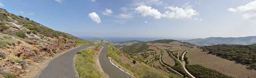
The Tour de Madeloc or Route Madeloc is a very small, narrow road located near the Spanish border and Cap Cerbere, in southern France. The route is part of the scenic Route des Cols and connects the coastal towns of Banyuls-Sur-Mer and Colliure.
Where is the road located?
The drive, known as the D86, is located in the Pyrénées-Orientales department of France, near the Mediterranean coast. It starts near sea level and climbs steeply to circa 450 meters within a short distance. The road leads through numerous vineyards and offers an incredible view toward the sea and the surrounding landscape in the higher regions.
What is the road surface and length like?
The road is about 18.5 kilometers long. The surface is always paved (with some areas recently renewed), but it is small and very winding. Expect some sections to be extremely steep, with gradients up to 20%.
What makes this road dangerous?
The D86 is notorious for its narrow sections, often having just enough space for one car. It is so narrow that even a car and a motorbike may struggle to pass. If two cars meet, one will surely have to go into reverse. There are no guardrails, and the sheer drop starts immediately aside the road. One failure can be fatal, meaning there is definitely no room for errors.
What essential advice should drivers follow?
Drivers should only attempt this road if they are very experienced, especially if they are not familiar with driving their car in reverse precisely over a longer distance. The recommended speed is limited to around 30 km/h so that you can stop at any moment if a vehicle comes surprisingly after the next bend. Incredible as it is, this road is constantly used by the local farmers who own the vineyards.
Are there viewing and rest points?
Yes, there are two places with orientation tables and secure places to stop and park your vehicle. Near the junction leading to the tower, there is a prepared rest place with desks and banks made of stone, offering room to park and fantastic views, though it has no shade.
Does the road lead to the Tour de Madeloc tower?
Yes, the road is named after the medieval watch tower. Starting from the D86 road, there is a dead-end track that ends at the tower. However, this road is closed to all traffic. The track is even tighter, the pavement is old and bad, and it features a hairpin bend that is so tight you will have trouble turning around if you ignore the restriction. It is better to have a short walk up to the tower.
What passes does the road cross?
The road goes up and down most of the journey and crosses several minor passes:
- Rec de Matifoc
- Coll de Llagastera
- Coll Dels Gascons
- College de Mollo
- Coll de la Serra
- Coll d´en Calvo
What other attractions are nearby?
Near the D86, there is an old castle called Fort Saint Elme, which has been completely renovated and operates as a museum. Major changes to the castle were made by Vauban (Marshal Sébastien Le Prestre de Vauban, 1633–1707), whose fortifications often become cultural heritage sites. The journey itself offers superb views and is definitely a drive you want to record with lots of photographs, making it an excellent place to use both telephoto and wide-angle lenses.
Road suggested by: Michael Spannlang