How to drive the steep track to Pointe des Mossettes?
Pointe des Mossettes is an international high mountain pass at an elevation of 2,252m (7,388ft) above sea level, located on the border between France (Haute-Savoie) and Switzerland (Valais). The summit is situated at the highest point of the Les Portes du Soleil ski domain, above Avoriaz. The access route is a mixed-surface road that is paved in the lower sections and turns into a technical unpaved track as it nears the summit, requiring a high-clearance 4x4 vehicle.
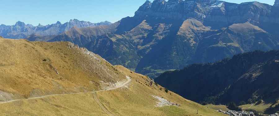
| Road facts: Pointe des Mossettes | |
|---|---|
| Location | Switzerland (Champéry) - France Border |
| Elevation | 2,252m (7,388ft) |
| Length | 12.8 km (from Champéry) |
| Average Gradient | 9.15% |
| Technical Features | 9 hairpins / 1,172m elevation gain |
What are the technical challenges of the Champéry to Pointe des Mossettes climb?
The 12.8 km ascent from Champéry involves a significant elevation gain of 1,172 meters. With an average gradient of 9.15%, the route is a sustained test for the vehicle's powertrain. The first sector is paved, but as the road enters the ski area, it transitions into a gravel track with 9 sharp hairpin turns. On the unpaved sections, the loose surface combined with the steep incline can lead to traction loss, especially on the inner side of the switchbacks. It is a technical requirement to use 4WD and maintain steady throttle control to navigate the segments where the gravel is not stabilized.
What are the logistics of driving through a ski domain?
Driving to Pointe des Mossettes requires navigating through active ski resort infrastructure. Logistically, this means being alert for heavy maintenance machinery and service vehicles that share the narrow track. The road is only open to motor vehicles during the summer months; from late autumn to early summer, the route is part of the ski slopes and is completely impassable. At the summit (2,252m), the space for maneuvering is restricted by the presence of chairlift stations. Ensure your vehicle is compact enough to execute a multi-point turn if the parking area near the Mossettes-Suisse lift is occupied.
How to manage engine and brake performance at 2,252 meters?
The 1,172-meter climb puts a heavy thermal load on the engine. At altitudes exceeding 2,000 meters, the cooling efficiency drops, making it essential to monitor the temperature gauge during the low-speed, high-torque segments. On the return journey, the 9.15% average descent back to Champéry is a high-risk sector for brake fade. You must utilize engine braking in a low gear to manage the 12.8 km decline. Relying solely on the brake pedal will cause the pads to overheat, potentially leading to a total loss of braking pressure before reaching the lower paved sections.
Vehicle preparation for the Pointe des Mossettes border ridge
A high-clearance 4x4 in optimal mechanical condition is mandatory for the Pointe des Mossettes track. Check tire pressures before leaving Champéry, as the sharp alpine rocks on the upper unpaved sections can cause punctures. It is a safety protocol to carry a full-size spare tire and basic recovery tools. Logistically, Champéry is the last point for fuel and mechanical support. Before starting the 12.8 km transit, verify the weather forecast for the Valais region, as sudden storms can turn the gravel track into a high-risk mud zone, significantly increasing the difficulty of the 9.15% ramps.
Pic: Alberto Docampo