Col de la Lariée: Driving the 1,964m military track on the French-Italian border
Col de la Lariée is a high mountain pass at an elevation of 1,964m (6,443ft) above sea level, located on the international border between France and Italy.
| Road facts: Col de la Lariée | |
|---|---|
| Location | France-Italy Border (Piedmont / Alpes-Maritimes) |
| Elevation | 1,964 m (6,443 ft) |
| Length | 650 m (0.4 miles) from Tanarello |
| Surface | Unpaved / Loose rocky scree |
Where is Col de la Lariée located?
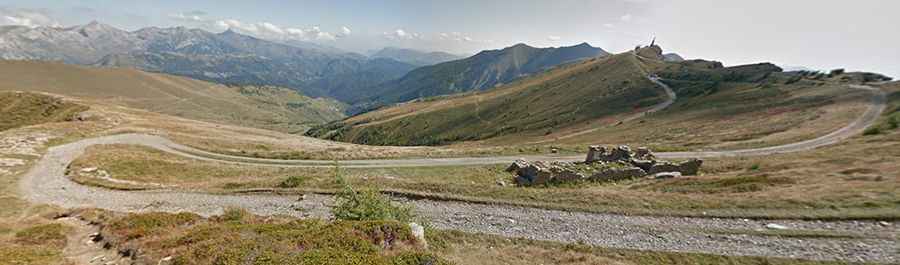
The pass connects the Alpes-Maritimes department with the Province of Cuneo. It is located just a short distance northwest of the Pas de Basera. It sits on the rugged limestone ridge that separates the Roya Valley in France from the Tanaro Valley in Italy.
Is Col de la Lariée a military road?
The road is a military track that follows the watershed line. It’s part of the historical border defenses, surrounded by ruins of early 20th-century bunkers and stone barracks. The track is integrated into the wider network of the Via del Sale (Salt Road) and other ridgeline military paths.
Is the road to Col de la Lariée unpaved?
The track is entirely unpaved, with loose gravel, crushed limestone, and natural bedrock. The surface is highly irregular, requiring a 4x4 vehicle with high ground clearance. It is narrow and exposed with no safety barriers or guardrails.
How to drive from Passo di Tanarello to Col de la Lariée?
The road from the well-known Passo di Tanarello to Col de la Lariée is approximately 650 meters long. Despite its short distance, it is a technical drive due to the elevation and the narrowness of the path. It is a slow-speed drive where you must be prepared to stop or reverse if you encounter motorcycles or other off-road vehicles, as passing space is extremely limited on the ridge.
Is Col de la Lariée open in winter?
Set high in the Ligurian Alps, the pass is usually impassable in winters. At this elevation, heavy snow drifts bury the military tracks, and ice remains in the shaded northern corners. There is no maintenance or snow removal on these border tracks.