Pas de l'Âne: Driving the brutal 17.4% ski track in the Massif des Cerces
Situated in the heart of the Hautes-Alpes department in southeastern France, Pas de l'Âne is a high mountain pass reaching an elevation of 2,475m (8,120ft) above sea level. Located within the rugged Massif des Cerces, this pass is not a conventional road but a grueling high-altitude track that serves as a vital service route for the ski infrastructure of the Serre Chevalier valley.
| Road facts: Pas de l'Âne | |
|---|---|
| Location | Hautes-Alpes, France (Massif des Cerces) |
| Elevation | 2,475 m (8,120 ft) |
| Coordinates | 44.94263, 6.49144 |
| Length | 5.5 km (3.4 miles) |
| Average Gradient | 17.41% |
Where is Pas de l'Âne?
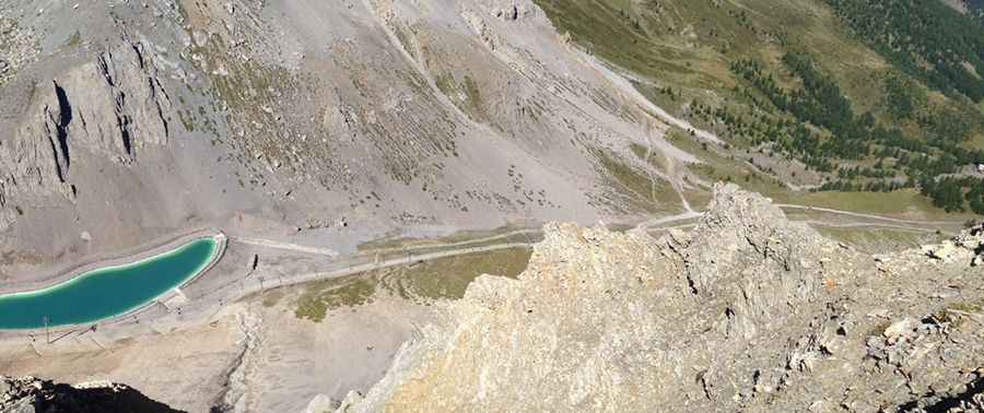
The pass is located at the coordinates 44.94263, 6.49144, in the Provence-Alpes-Côte d'Azur region. It perches high above the town of Le Monêtier-les-Bains, dominating the landscape of the Cerces range. The geographic position offers panoramic views of the Ecrins National Park, but for drivers, the focus remains entirely on the narrow path that clings to the steep limestone ridges of the northern Serre Chevalier sector.
Is Pas de l'Âne unpaved?
Yes, the road to the summit is totally unpaved. It is a dedicated chairlift service road, designed for heavy-duty maintenance vehicles rather than civilian traffic. The route is a narrow single track that can be extremely intimidating for those without a head for heights. The path features dangerous drops and no safety barriers. A high-clearance 4x4 vehicle with low-range gearing is mandatory; the loose gravel combined with the extreme incline makes traction a constant struggle, especially on the tighter hairpins where the vehicle's center of gravity is tested.
How long is the road to Pas de l'Âne?
Starting from Le Monêtier-les-Bains, the road to the summit is 5.5 km (3.4 miles) long. Despite the short distance, the elevation gain is a staggering 958 meters. This creates an average gradient of 17.41%, a figure that ranks among the steepest motorable tracks in the French Alps. There are virtually no flat sections to allow the engine or brakes to cool down. Navigating this climb requires professional-level off-road skills to manage the continuous vertical ascent without overheating the transmission.
Is the road to Pas de l'Âne open in winter?
No, set high in the Massif des Cerces, the road is completely impassable in winter. As it sits in the middle of an active ski area, the track is covered by several meters of snow for most of the year. It typically only becomes clear for 4x4 vehicles from late June to September. Even in summer, sudden mountain storms can turn the 17.4% dirt grade into a slippery mud slide, making the descent towards the valley as dangerous as the climb. Always check the weather forecast before attempting this high-intensity Alpine ascent.
Pic: Jakub Škuta