How to drive the unpaved road to Pas de Coterieux?
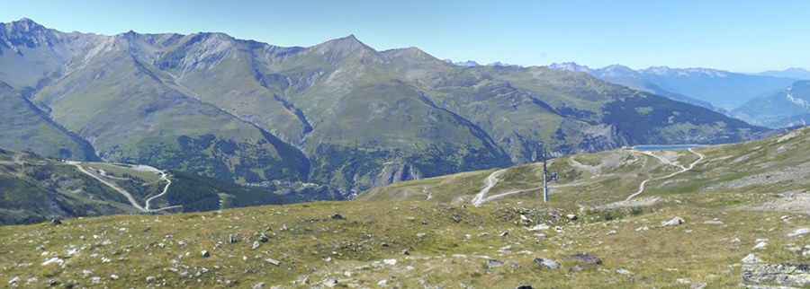
Pas de Coterieux is a high mountain pass at an elevation of 2,526m (8,287ft) above sea level, located in the Savoie department within the Auvergne-Rhône-Alpes region of south-eastern France. Situated in the Massif des Cerces range, the road to the pass is a technical unpaved trail used primarily for chairlift maintenance. Logistically, this high-altitude corridor is a branch of the mountain infrastructure near Valmeinier and provides a technical off-road link within the shadow of the Col du Galibier area.
| Road facts: Pas de Coterieux | |
|---|---|
| Location | Savoie, Auvergne-Rhône-Alpes, France |
| Elevation | 2,526 m (8,287 ft) |
| Length | 6.8 km (4.2 miles) |
| Surface | Unpaved (Gravel / Loose Rock) |
| Technical Requirement | High-clearance 4x4 mandatory |
What is the technical condition of the road to Pas de Coterieux?
The 6.8 km ascent to Pas de Coterieux starts from the paved D215A Road, near Valmeinier. Technically, the road is a high-altitude maintenance track characterized by loose shale and compacted gravel. Logistically, the roadbed is designed for utility 4x4 vehicles and heavy machinery used in ski lift operations. The track features steep gradients that require precise traction management, especially in sectors where meltwater erosion has created cross-grooves. A high-clearance vehicle is mandatory to avoid underbody impacts on the irregular rocky sections of the Massif des Cerces.
How to manage the logistics of the 2,526m climb from Valmeinier?
The transition from the paved D215A to the 2,526m summit involves a significant change in vehicle logistics. Technically, the 6.8 km stretch requires low-range gearing to maintain a steady crawl on the unpaved ramps. Logistically, the narrowness of the track and the lack of passing points mean that uphill traffic must be prioritized. Drivers must account for the decreasing air density at 2,526m, which affects engine cooling efficiency during the slow, high-torque climb. The route is highly exposed, with vertical drops that require disciplined steering and constant monitoring of the edge stability.
What is the operational window for the Pas de Coterieux pass?
Due to its high elevation in the Savoie Alps, Pas de Coterieux is usually impassable from October to June. Logistically, the road is not cleared of snow, as it serves seasonal maintenance purposes. Technically, the track may remain blocked by snowdrifts well into the summer months depending on the previous winter's accumulation. It is a mandatory safety protocol to verify the track status in Valmeinier before starting the 6.8 km transit. During the open window (July-September), the primary technical hazard is localized rockfall and sudden alpine thunderstorms that can wash out sections of the unpaved surface in minutes.
Safety protocols for driving in the Massif des Cerces
Logistically, the area around Pas de Coterieux is isolated from immediate mechanical support. Technically, the vehicle's braking system must be in optimal condition, as the descent back towards Valmeinier requires sustained engine braking to manage the steep Alpine grades. It is a mandatory requirement to carry recovery gear, including a full-size spare tire and tools for basic trail repairs. The proximity to high-traffic areas like the Galibier does not mean the Pas de Coterieux is easily accessible; it remains a technical mountain track where self-sufficiency is the only logistical guarantee for a safe transit.
Pic: Jérôme Deschamps