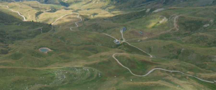
How to drive the long climb to Pointe du Dzonfié?
The climb to Pointe du Dzonfié is a long, technical ascent in the Savoie department of the French Alps. Reaching 2,185m (7,168ft) above sea level, this route is a mix of high-alpine paved roads and rough mountain tracks. Spanning 31 kilometers from the valley floor, it requires a vehicle with good ground clearance and a driver who knows how to manage brake heat and gear selection on narrow, unprotected ledge roads.
| Road facts: Pointe du Dzonfié | |
|---|---|
| Location | Savoie, Auvergne-Rhône-Alpes, France |
| Length | 31.0 km (from Grand-Aigueblanche) |
| Max Elevation | 2,185m (7,168ft) |
| Hairpin Turns | 38 |
| Surface | Paved base / Gravel summit track |
How to drive the 38 hairpins to Pointe du Dzonfié?
Starting from Grand-Aigueblanche, the road to Pointe du Dzonfié is a marathon for your vehicle. The first section is paved but narrow, winding through alpine villages before the surface changes to gravel as you climb higher. The 38 hairpin turns are the real test; many are tight and require precise steering, especially if you encounter local farm vehicles or hikers. As you get closer to the Refuge du Nant du Beurre, the track becomes more rugged. You’ll need a 4x4 or at least a high-clearance vehicle to handle the ruts and loose stones near the summit without damaging your oil pan or suspension.
What are the mechanical risks on the Savoie mountain tracks?
The biggest mechanical challenge here isn't the climb—it's the 31 km descent. Going down from 2,185m to the valley floor will cook your brakes if you rely only on the pedal. You must use engine braking by keeping the car in a low gear. On the unpaved sections, the terrain can be unpredictable; after heavy rain, the gravel turns into slick mud, making traction difficult even for 4x4s. Always check your tire sidewalls for cuts from sharp alpine rocks. In the summer, cow herds often block the road, so keep your speed low on blind corners to avoid emergency braking on loose surfaces.
Weather and logistical planning for the Refuge du Nant du Beurre
Logistically, this isn't a route to take lightly. While the lower parts are accessible, the summit track is usually blocked by snow from late October until June. Even in July, a sudden mountain storm can drop the temperature to near freezing and turn the track into a washboard. There is no fuel or mechanical help once you leave the valley, so make sure your tank is full before leaving Grand-Aigueblanche. If you plan to stop at the Refuge du Nant du Beurre, remember that the road is very narrow with few passing places; if you meet another vehicle, one of you will have to back up, often on a steep incline next to a drop-off.
Technical safety on narrow alpine ledges
Safety on the Pointe du Dzonfié track comes down to knowing your vehicle's width and its limits. Some sections of the gravel path are barely wide enough for a single truck, with deep drops on one side and rock walls on the other. Always yield to vehicles coming uphill—it's much harder for them to restart on a steep gravel incline than it is for you to wait. Ensure your 4WD system is working correctly before the surface turns to dirt, and keep an eye on the weather forecast; getting stuck at 2,000m during a Savoie thunderstorm is a situation you want to avoid.
Pic: Ebafin Lothac