The old military road to Col de l’Infernet in the Hautes-Alpes
Col de l’Infernet is a high mountain peak at an elevation of 2,355m (7,726ft) above sea level, located in the Hautes-Alpes department of France.
Where is Col de l’Infernet?
The peak is located near Briançon, in the Provence-Alpes-Côte d'Azur region in the southeastern part of the country.
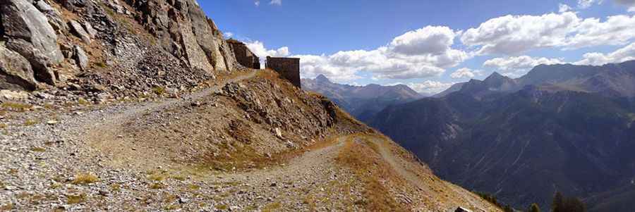
What’s Fort de l’Infernet?
At the summit, there’s an old fort called Fort de l’Infernet. It is a 19th-century French fortification, built between 1876 and 1878 as part of the Séré de Rivières system to defend France from potential Italian invasion. Positioned at 2,380 metres (7,810 ft), it overlooked the Durance Valley and the Fort du Gondran, and was the last French fort built with cut stone masonry.
The fort, accessible by a mule-powered aerial tramway linked to Fort du Randouillet, housed a 210-man garrison and an extensive artillery arsenal including 138 mm, 155 mm, and 220 mm guns and mortars. In 1940, during World War II, it served as a support fortification for the Alpine Line and successfully returned fire on Italian forces bombarding it from Fort Mont Chaberton, silencing their guns.
Is the road to Col de l’Infernet unpaved?
The road to the summit is totally unpaved and very exposed, with a high accident risk. It’s an old military trail designed for army vehicles. It comprises steep and narrow parts, with dangerous slippery sections and severe drops. A 4x4 vehicle is required.
How long is the road to Col de l’Infernet?
Starting from the paved D902 Road, the road to the summit is about 9km (5.5 miles) long. Over this distance, the elevation gain is 941 m, and the average gradient is 10.45%. Along the way, you’ll pass endless old forts, gun placements, and barracks. The drive provides stunning views over the Clarée, the Guisane, and Briançon.
Is the road to Col de l’Infernet open in winter?
Set high in the French Alps, the road is usually impassable in winter, though it can be closed anytime due to snow.
Pic: Jan Liska