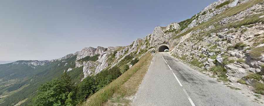
Driving the D199 road through Col de la Bataille in the Vercors
Col de la Bataille is a mountain pass at an elevation of 1,313 meters (4,307 ft) above sea level, located in the Drôme department, in the Auvergne-Rhône-Alpes region of France. Situated within the Vercors Massif, the pass is crossed by the paved D199 road.
| Road facts: Col de la Bataille (D199) | |
|---|---|
| Location | Drôme, Vercors (France) |
| Elevation (Pass) | 1,313 m (4,307 ft) |
| Max Elevation (Tunnel) | 1,336 m (4,383 ft) |
| Length from Léoncel | 11.4 km (7.08 miles) |
| Elevation Gain | 536 m (1,758 ft) |
| Average Gradient | 4.70% |
| Surface | Paved |
How steep is the D199 road to Col de la Bataille?
Starting from Léoncel, the drive to the summit spans 11.4 kilometers (7.08 miles) with an elevation gain of 536 meters. The D199 road is fully paved and averages a 4.70% gradient, though several ramps through the forest reach steeper percentages. The highest point on the drive is not the open pass itself, but the Tunnel du Col de la Bataille at 1,336 meters elevation—a narrow, rock-cut tunnel where lanes narrow down significantly.
What are the driving hazards on Col de la Bataille?
The D199 runs along exposed cliff sections in the Vercors mountains, where strong crosswinds regularly hit high-profile vehicles along the ridges. Water runoff causes rockfalls near the tunnel entrances, leaving loose stones on the asphalt. On the long descent back toward Léoncel, drivers should shift into lower gears to use engine braking and avoid overheating the brake pads on the tight turns.
Is Col de la Bataille open in winter?
No. Due to heavy snowfall and ice accumulation on the cliffs above the road, the Col de la Bataille is closed to traffic during the winter months, typically from November through April or early May. Snowplows clear the D199 once the spring thaw reduces the risk of avalanches and rockslides onto the roadbed.