Driving the Strada Militare dello Chaberton: Europe’s highest dead-end road
The military road to Colle delle Chaberton is not just a high-altitude track; it is a test of mechanical endurance and nerves. Rising to 2,674 meters in the French Alps, this unpaved route is famous for its extreme gradients and the way the mountain is slowly reclaiming the asphalt. If you plan to drive the Strada Militare dello Chaberton, you need to understand that beyond a certain point, the road simply ceases to exist for conventional vehicles.
| Road facts: Colle delle Chaberton | |
|---|---|
| Location | Fénils (Italy) to Hautes-Alpes (France) |
| Max Elevation | 2,674m (8,772ft) |
| Terrain | Loose shale, deep ruts, and rockfalls |
| Status | Partially impassable above 2,300m |
The Fénils Ascent: Managing the first gradients
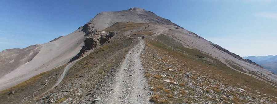
Starting from the village of Fénils in the Susa Valley, the road—also known as Strada Militare di Val Morino—begins with a deceptive series of hairpins. The lower sections are manageable, but as you gain altitude, the surface turns into a mix of loose shale and deep ruts. This is where the physical reality of the road hits: the gradients are sustained and steep. You need a 4x4 with a low-range transfer case just to maintain a steady pace without cooking the clutch.
The 2,300m Barrier: Where the mountain wins
As you reach the 2,300-meter mark, the road conditions deteriorate rapidly. What used to be a wide military carriage road is now a narrow, unstable ledge. Frequent landslides and the lack of maintenance since the late 80s have made the upper sections impassable for almost any standard expedition vehicle. The technical challenge is not just the height, but the "instability of the shelf". The edges are crumbling, and in some parts, you are driving on a bed of loose rocks that can slide toward the precipice. It is a dead-end road where the higher you go, the more you have to rely on your ability to reverse in tight spaces if the path ahead is blocked by a recent rockfall.
Mechanical stress and oxygen deprivation
At nearly 2,700 meters, your vehicle’s engine will struggle. The lack of oxygen means a significant loss of power, making the steep climbs even more difficult. This is a road that demands mechanical sympathy; you have to monitor your cooling system and be aware that the thin air affects your brakes' ability to shed heat during the descent. Navigating the Chaberton is an exercise in managing the vehicle's limits in an environment that was never designed for civilian comfort. It is Europe's highest unpaved military road, and it shows its age and its teeth in every kilometer.
Is it still driveable to the summit?
In present days, the summit of Monte Chaberton—with its iconic eight masonry towers—is more a target for hikers and extreme mountain bikers than for cars. While authorized vehicles occasionally attempt the lower parts, the "Fenils-Chaberton road" is largely a relic of 19th-century engineering that is being erased by the Alpine winters. It remains, however, a legendary name when discussing the highest mountain roads of France, standing as a brutal reminder of how quickly a military road can turn into an impassable boulder field. If you attempt to drive here, you are entering a zone of high-consequence navigation where a mechanical failure means a very long walk and a very expensive recovery mission. Respect the altitude and the stones; the Chaberton doesn't forgive mistakes.
Pic: Sandro Cadeddu