Driving the scenic Col de la Core in the heart of the Ariège Pyrenees
Col de la Core is a high mountain pass at an elevation of 1,395m (4,577ft) above sea level, located in the Ariège department of the French Pyrenees. This pass is a staple of the Tour de France and serves as a vital link between the Bethmale Valley and the Salat Valley.
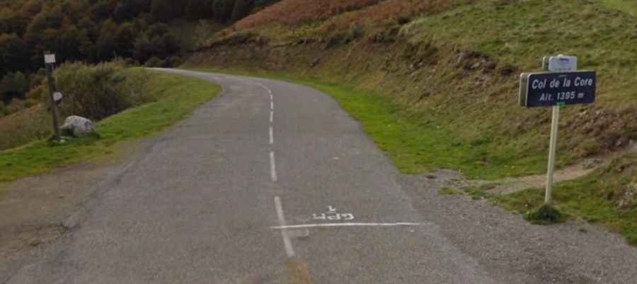
The pass is situated within the Regional Natural Park of the Ariège Pyrenees, an area known for being much greener and more isolated than the high peaks of the central range. The drive is famous for its pastoral scenery, with cattle often grazing near the road and dense beech forests that provide shade during the summer. The summit offers a wide, open plateau with panoramic views of the Mont Valier massif, the iconic peak of this region.
| Road facts: Col de la Core | |
|---|---|
| Location | Ariège, Pyrenees (France) |
| Elevation | 1,395 m (4,577 ft) |
| Road Name | D17 |
| Length | 31 km (19.2 miles) |
| Max Gradient | 9.6% |
| Surface | Paved / Asphalt |
How is the drive to the summit of Col de la Core?
The road through the pass, the D17, is 31 km long, running north-south from Audressein to Seix. It is a fully paved route, but it has the typical character of Ariège roads: winding, narrow in some sections, and often without guardrails. While the road is not "dangerous" in dry conditions, it requires focus due to the tight curves and the possibility of encountering livestock or cyclists on the blind bends.
There are two main routes to reach the top, and both are classic cycling climbs:
- From Seix (East): This is the steeper side. The ascent is 13.8 km long with an average gradient of 6.4%. The road hits several sections at 8-9%, winding through woods before opening up near the top.
- From Audressein (West): A longer, more gradual climb of 17.5 km. The average percentage is 5.1%, making it a smoother drive through the beautiful Bethmale Valley.
The asphalt is generally in good condition, but during autumn, the road can be covered in wet leaves, making the tight turns surprisingly slippery.
When is the best time to drive Col de la Core?
Unlike the higher giants of the Pyrenees, Col de la Core is at a relatively modest altitude, but it can still be closed during heavy winter storms. Usually, the road is open for most of the year, though snow tires or chains are mandatory in winter. The best time for a road trip is late spring to early autumn. In summer, the pass is much cooler than the plains below, but watch out for the occasional mountain fog that can settle in the Bethmale Valley, reducing visibility to nearly zero in the forested sections.